
Nanchang topographic map
Interactive map
Click on the map to display elevation.
About this map
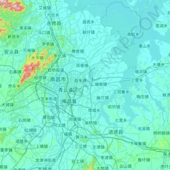
Name: Nanchang topographic map, elevation, terrain.
Location: Nanchang, Jiangxi, China (28.16067 115.43426 29.19248 116.56084)
Average elevation: 141 ft
Minimum elevation: 23 ft
Maximum elevation: 3,045 ft
Der Stern von Nanchang ist eines der größten Riesenräder der Welt (Höhe 160 m, Durchmesser 153 m; Baukosten ca. 57 Mio. Yuan (≈ 6 Mio. €); Einweihung am 2. Mai 2006).
Other topographic maps
Click on a map to view its topography, its elevation and its terrain.