
Make a donation
Gear up for your next adventure:
As an Amazon Associate, this site earns from qualifying purchases at no extra cost to you.
Grand Canyon South Rim topographic map
Click on the map to display elevation.
Make a donation
Gear up for your next adventure:
As an Amazon Associate, this site earns from qualifying purchases at no extra cost to you.
About this map
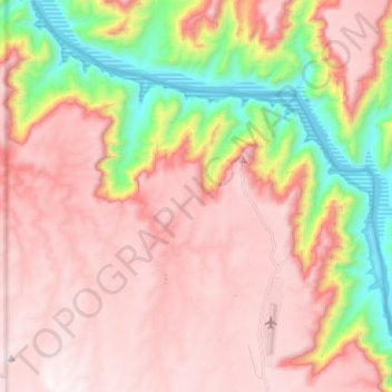
Name: Grand Canyon South Rim topographic map, elevation, terrain.
Average elevation: 3,550 ft
Minimum elevation: 1,155 ft
Maximum elevation: 5,112 ft
Mohave County trails, hiking, mountain biking, running and outdoor activities
Make a donation
Gear up for your next adventure:
As an Amazon Associate, this site earns from qualifying purchases at no extra cost to you.
Other topographic maps
Click on a map to view its topography, its elevation and its terrain.
Oatman
United States > Arizona > Mohave County
Oatman is a census-designated place (CDP) in the Black Mountains of Mohave County, Arizona, United States, at an elevation of 2,710 feet (830 m). In 1915, it began as a small mining camp when two prospectors struck US$10 million (equivalent to $176 million in 2024) in gold, though the vicinity had already been…
Average elevation: 2,933 ft
Make a donation
Gear up for your next adventure:
As an Amazon Associate, this site earns from qualifying purchases at no extra cost to you.
Bullhead City
United States > Arizona > Mohave County
Hardyville Pioneer Cemetery, a small cemetery, now a historic landmark at 35°7′16″N 114°35′17″W / 35.12111°N 114.58806°W / 35.12111; -114.58806, is the most significant existing remnant of Hardyville. An unofficial historical marker for the town is in the parking lot across Highway 95 from…
Average elevation: 1,076 ft
Make a donation
Gear up for your next adventure:
As an Amazon Associate, this site earns from qualifying purchases at no extra cost to you.
Antares
United States > Arizona > Mohave County > Antares
Antares is located in northwestern Arizona, in central Mohave County, 21 miles (34 km) northeast of Kingman, the county seat. The Antares census-designated place encompasses 0.65 square miles (1.7 km2) of land, and is at 3,556 feet (1,084 m) elevation above sea level. The southern edge of the CDP follows State…
Average elevation: 3,478 ft
Make a donation
Gear up for your next adventure:
As an Amazon Associate, this site earns from qualifying purchases at no extra cost to you.
Kingman
United States > Arizona > Mohave County
Lt. Edward Fitzgerald Beale, a U.S. Navy officer in the service of the Army Corps of Topographical Engineers, was ordered by the U.S. War Department to build a federal wagon road across the 35th parallel. His secondary orders were to test the feasibility of the use of camels as pack animals in the Southwestern…
Average elevation: 3,711 ft
Make a donation
Gear up for your next adventure:
As an Amazon Associate, this site earns from qualifying purchases at no extra cost to you.
Make a donation
Gear up for your next adventure:
As an Amazon Associate, this site earns from qualifying purchases at no extra cost to you.
Make a donation
Gear up for your next adventure:
As an Amazon Associate, this site earns from qualifying purchases at no extra cost to you.
Kingman
United States > Arizona > Mohave County
Lt. Edward Fitzgerald Beale, a U.S. Navy officer in the service of the Army Corps of Topographical Engineers, was ordered by the U.S. War Department to build a federal wagon road across the 35th parallel. His secondary orders were to test the feasibility of the use of camels as pack animals in the Southwestern…
Average elevation: 3,711 ft
Make a donation
Gear up for your next adventure:
As an Amazon Associate, this site earns from qualifying purchases at no extra cost to you.
Make a donation
Gear up for your next adventure:
As an Amazon Associate, this site earns from qualifying purchases at no extra cost to you.
Pigeon Point Lighthouse
United States > Arizona > Mohave County > Lake Havasu City
Average elevation: 509 ft
Make a donation
Gear up for your next adventure:
As an Amazon Associate, this site earns from qualifying purchases at no extra cost to you.
Bullhead City
United States > Arizona > Mohave County
Hardyville Pioneer Cemetery, a small cemetery, now a historic landmark at 35°7′16″N 114°35′17″W / 35.12111°N 114.58806°W / 35.12111; -114.58806, is the most significant existing remnant of Hardyville. An unofficial historical marker for the town is in the parking lot across Highway 95 from…
Average elevation: 1,056 ft
Make a donation
Gear up for your next adventure:
As an Amazon Associate, this site earns from qualifying purchases at no extra cost to you.
Bullhead City
United States > Arizona > Mohave County
Hardyville Pioneer Cemetery, a small cemetery, now a historic landmark at 35°7′16″N 114°35′17″W / 35.12111°N 114.58806°W / 35.12111; -114.58806, is the most significant existing remnant of Hardyville. An unofficial historical marker for the town is in the parking lot across Highway 95 from…
Average elevation: 1,076 ft
Kingman
United States > Arizona > Mohave County
Lt. Edward Fitzgerald Beale, a U.S. Navy officer in the service of the Army Corps of Topographical Engineers, was ordered by the U.S. War Department to build a federal wagon road across the 35th parallel. His secondary orders were to test the feasibility of the use of camels as pack animals in the Southwestern…
Average elevation: 3,707 ft
Make a donation
Gear up for your next adventure:
As an Amazon Associate, this site earns from qualifying purchases at no extra cost to you.
Kingman
United States > Arizona > Mohave County > Kingman
Lt. Edward Fitzgerald Beale, a U.S. Navy officer in the service of the U.S. Army Corps of Topographical Engineers, was ordered by the U.S. War Department to build a federal wagon road across the 35th Parallel. His secondary orders were to test the feasibility of the use of camels as pack animals in the…
Average elevation: 3,724 ft