
Make a donation
Gear up for your next adventure:
As an Amazon Associate, this site earns from qualifying purchases at no extra cost to you.
San Mateo topographic map
Click on the map to display elevation.
Make a donation
Gear up for your next adventure:
As an Amazon Associate, this site earns from qualifying purchases at no extra cost to you.
About this map
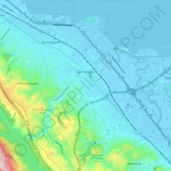
Name: San Mateo topographic map, elevation, terrain.
Location: San Mateo, San Mateo County, California, United States (37.51281 -122.35491 37.59930 -122.27459)
Average elevation: 157 ft
Minimum elevation: -20 ft
Maximum elevation: 1,093 ft
San Mateo County trails, hiking, mountain biking, running and outdoor activities
Make a donation
Gear up for your next adventure:
As an Amazon Associate, this site earns from qualifying purchases at no extra cost to you.
Other topographic maps
Click on a map to view its topography, its elevation and its terrain.
Red Morton Community Park
United States > California > San Mateo County > Redwood City
Average elevation: 59 ft
Make a donation
Gear up for your next adventure:
As an Amazon Associate, this site earns from qualifying purchases at no extra cost to you.
Bayshore Heights Park
United States > California > San Mateo County > Daly City
Average elevation: 276 ft
Redwood Junction
United States > California > San Mateo County > Redwood City
Average elevation: 30 ft
Make a donation
Gear up for your next adventure:
As an Amazon Associate, this site earns from qualifying purchases at no extra cost to you.
Hillsborough Park
United States > California > San Mateo County > Hillsborough
Average elevation: 325 ft
Make a donation
Gear up for your next adventure:
As an Amazon Associate, this site earns from qualifying purchases at no extra cost to you.
Redwood Junction
United States > California > San Mateo County > Redwood City
Average elevation: 30 ft
Make a donation
Gear up for your next adventure:
As an Amazon Associate, this site earns from qualifying purchases at no extra cost to you.
Make a donation
Gear up for your next adventure:
As an Amazon Associate, this site earns from qualifying purchases at no extra cost to you.
Make a donation
Gear up for your next adventure:
As an Amazon Associate, this site earns from qualifying purchases at no extra cost to you.
Hillsborough Park
United States > California > San Mateo County > Hillsborough
Average elevation: 325 ft
Make a donation
Gear up for your next adventure:
As an Amazon Associate, this site earns from qualifying purchases at no extra cost to you.
Half Moon Bay
United States > California > San Mateo County > Half Moon Bay > Half Moon Bay
Average elevation: 240 ft
Daly City
United States > California > San Mateo County > Daly City
Several golf courses are located within or straddle the border with San Francisco. The Olympic Club has hosted the USGA U.S. Open five times, most recently in 2012, and will host both the 2028 PGA Championship and the 2032 Ryder Cup. The private San Francisco Golf Club and Lake Merced Golf Club have part or…
Average elevation: 105 ft
Make a donation
Gear up for your next adventure:
As an Amazon Associate, this site earns from qualifying purchases at no extra cost to you.
Brisbane
United States > California > San Mateo County > Brisbane > Brisbane
Average elevation: 167 ft
San Carlos
United States > California > San Mateo County > San Carlos > San Carlos
Average elevation: 154 ft
Highlands
United States > California > San Mateo County > San Mateo Highlands
Average elevation: 423 ft
Make a donation
Gear up for your next adventure:
As an Amazon Associate, this site earns from qualifying purchases at no extra cost to you.