
Grabtown topographic map
Click on the map to display elevation.
About this map
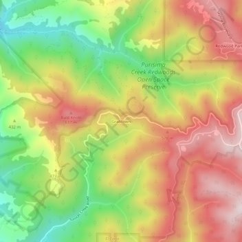
Name: Grabtown topographic map, elevation, terrain.
Location: Grabtown, San Mateo County, California, United States (37.40216 -122.36386 37.44216 -122.32386)
Average elevation: 1,437 ft
Minimum elevation: 479 ft
Maximum elevation: 2,320 ft
Other topographic maps
Click on a map to view its topography, its elevation and its terrain.
Daly City
United States > California > San Mateo County
Several golf courses are located within or straddle the border with San Francisco. The Olympic Club has hosted the USGA U.S. Open five times, most recently in 2012, and will host both the 2028 PGA Championship and the 2032 Ryder Cup. The private San Francisco Golf Club and Lake Merced Golf Club have part or…
Average elevation: 246 ft
Montara
United States > California > San Mateo County > Montara
The rare and endangered species Hickman's potentilla occurs at the northern extremity of Montara on the slopes above Martini Creek at elevations ranging from 32 to 410 ft (9.8 to 125.0 m).
Average elevation: 217 ft
Red Morton Community Park
United States > California > San Mateo County > Redwood City
Average elevation: 59 ft
San Bruno
United States > California > San Mateo County
According to the United States Census Bureau, the city has a total area of 5.5 square miles (14 km2), all of it land. The city spreads from the mostly flat lowlands near San Francisco Bay into the foothills of the Santa Cruz Mountains, which rise to more than 600 feet (180 m) above sea level in Crestmoor and…
Average elevation: 348 ft
Bayshore Heights Park
United States > California > San Mateo County > Daly City
Average elevation: 276 ft
Hillsborough
United States > California > San Mateo County
According to the United States Census Bureau, the town has a total area of 6.2 square miles (16 km2), all of it land. The area's considerably winding, hilly topography, and impossibility of a grid layout make Hillsborough notoriously challenging to navigate. Many lots include fairly steep slopes, particularly…
Average elevation: 328 ft
Mission Hills Park
United States > California > San Mateo County > Daly City
Average elevation: 427 ft
San Bruno
United States > California > San Mateo County
According to the United States Census Bureau, the city has a total area of 5.5 square miles (14 km2), all of it land. The city spreads from the mostly flat lowlands near San Francisco Bay into the foothills of the Santa Cruz Mountains, which rise to more than 600 feet (180 m) above sea level in Crestmoor and…
Average elevation: 174 ft
West Menlo Park
United States > California > San Mateo County > West Menlo Park
Average elevation: 167 ft
Daly City
United States > California > San Mateo County
Several golf courses are located within or straddle the border with San Francisco. The Olympic Club has hosted the USGA U.S. Open five times, most recently in 2012, and will host both the 2028 PGA Championship and the 2032 Ryder Cup. The private San Francisco Golf Club and Lake Merced Golf Club have part or…
Average elevation: 246 ft
Montara
United States > California > San Mateo County > Montara
The rare and endangered species Hickman's potentilla occurs at the northern extremity of Montara on the slopes above Martini Creek at elevations ranging from 32 to 410 ft (9.8 to 125.0 m).
Average elevation: 554 ft
San Bruno
United States > California > San Mateo County
According to the United States Census Bureau, the city has a total area of 5.5 square miles (14 km2), all of it land. The city spreads from the mostly flat lowlands near San Francisco Bay into the foothills of the Santa Cruz Mountains, which rise to more than 600 feet (180 m) above sea level in Crestmoor and…
Average elevation: 348 ft
Hillsborough
United States > California > San Mateo County
According to the United States Census Bureau, the town has a total area of 6.2 square miles (16 km2), all of it land. The area's considerably winding, hilly topography, and impossibility of a grid layout make Hillsborough notoriously challenging to navigate. Many lots include fairly steep slopes, particularly…
Average elevation: 328 ft