Geolocate

Majuli topographic map

Click on the map to display elevation.

About this map

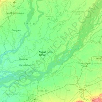
Name: Majuli topographic map, elevation, terrain.

Location: Majuli, Assam, India (26.86636 93.95658 27.18220 94.59287)

Average elevation: 295 ft

Minimum elevation: 240 ft

Maximum elevation: 525 ft

Other topographic maps

Click on a map to view its topography, its elevation and its terrain.

Jorabat

India > Assam > Sonapur

Average elevation: 499 ft

Diphu

India > Assam > Diphu

Diphu is located at 25°50′N 93°26′E / 25.83°N 93.43°E / 25.83; 93.43. It has an average elevation of 186 metres (610 feet). It is about 270 km by road and 213 km by railways from Guwahati. The town is located on a beautiful hill.

Average elevation: 630 ft

Tezpur

India > Assam > Tezpur

Average elevation: 223 ft

Subansiri

India > Assam > Gogamukh

Average elevation: 315 ft

Kāmrūp

India > Assam

Average elevation: 1,083 ft

Badarpur

India > Assam > Badarpur > Badarpur

Average elevation: 89 ft

Numaligarh

India > Assam > Bokakhat > Numaligarh

Average elevation: 285 ft

Gear up for your next adventure:

🎒Trail Energy Bars - High‑calorie bars for hiking energy
🚗GPS Dash Cams - Record your scenic drives through mountain passes and canyons
Camping Coffee Makers - Enjoy premium coffee at the summit or campsite
🔋Solar Power Banks - Keep your GPS and phone charged in remote wilderness areas
🪶LED Camping Lantern - Bright lantern for camp lighting

As an Amazon Associate, this site earns from qualifying purchases at no extra cost to you.