
Make a donation
Gear up for your next adventure:
As an Amazon Associate, this site earns from qualifying purchases at no extra cost to you.
Morrisville topographic map
Click on the map to display elevation.
Make a donation
Gear up for your next adventure:
As an Amazon Associate, this site earns from qualifying purchases at no extra cost to you.
Morrisville
Morrisville is located in the northeast central region of North Carolina, where the North American Piedmont and Atlantic Coastal Plain regions meet. This area is known as the "Fall Line" because it marks the elevation inland at which waterfalls begin to appear in creeks and rivers. As a result, most of Morrisville features gently rolling hills that slope eastward toward the state's flat coastal plain. Its central Piedmont location situates the county approximately three hours west of Atlantic Beach by car and four hours east of the Great Smoky Mountains.
Make a donation
Gear up for your next adventure:
As an Amazon Associate, this site earns from qualifying purchases at no extra cost to you.
About this map
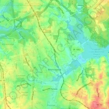
Name: Morrisville topographic map, elevation, terrain.
Average elevation: 351 ft
Minimum elevation: 259 ft
Maximum elevation: 499 ft
Wake County trails, hiking, mountain biking, running and outdoor activities
Make a donation
Gear up for your next adventure:
As an Amazon Associate, this site earns from qualifying purchases at no extra cost to you.
Other topographic maps
Click on a map to view its topography, its elevation and its terrain.
Make a donation
Gear up for your next adventure:
As an Amazon Associate, this site earns from qualifying purchases at no extra cost to you.
Lake Johnson
United States > North Carolina > Wake County > Raleigh > Orchards
Average elevation: 397 ft
Prestonwood Soccer Complex
United States > North Carolina > Wake County > Cary
Average elevation: 364 ft
Lake Raleigh
United States > North Carolina > Wake County > Raleigh > Isle Forest
Average elevation: 341 ft
Make a donation
Gear up for your next adventure:
As an Amazon Associate, this site earns from qualifying purchases at no extra cost to you.
Make a donation
Gear up for your next adventure:
As an Amazon Associate, this site earns from qualifying purchases at no extra cost to you.
Make a donation
Gear up for your next adventure:
As an Amazon Associate, this site earns from qualifying purchases at no extra cost to you.