
Make a donation
Gear up for your next adventure:
As an Amazon Associate, this site earns from qualifying purchases at no extra cost to you.
Exhibition Park topographic map
Click on the map to display elevation.
Make a donation
Gear up for your next adventure:
As an Amazon Associate, this site earns from qualifying purchases at no extra cost to you.
About this map
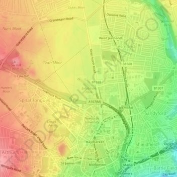
Name: Exhibition Park topographic map, elevation, terrain.
Average elevation: 210 ft
Minimum elevation: 13 ft
Maximum elevation: 354 ft
Make a donation
Gear up for your next adventure:
As an Amazon Associate, this site earns from qualifying purchases at no extra cost to you.
Other topographic maps
Click on a map to view its topography, its elevation and its terrain.
Newburn
United Kingdom > England > Newcastle upon Tyne
In 1855, William Whellan's History, Topography, and Directory of Northumberland described the banks of the Tyne at this point having extensive iron works, coal staithes, brickyards, chemical works and other manufactories.
Average elevation: 190 ft
Make a donation
Gear up for your next adventure:
As an Amazon Associate, this site earns from qualifying purchases at no extra cost to you.
Hazlerigg
United Kingdom > England > Newcastle upon Tyne > Hazlerigg Village
Average elevation: 217 ft
Middle Brunton
United Kingdom > England > Newcastle upon Tyne > Hazlerigg Village
Average elevation: 207 ft
Make a donation
Gear up for your next adventure:
As an Amazon Associate, this site earns from qualifying purchases at no extra cost to you.