Geolocate

Callerton topographic map

Click on the map to display elevation.

About this map

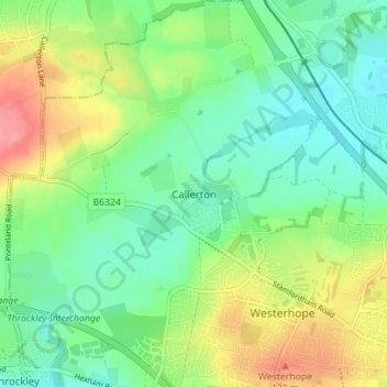
Name: Callerton topographic map, elevation, terrain.

Location: Callerton, Newcastle upon Tyne, North East, England, NE5 1NY, United Kingdom (54.99403 -1.74329 55.03403 -1.70329)

Average elevation: 299 ft

Minimum elevation: 203 ft

Maximum elevation: 472 ft

Other topographic maps

Click on a map to view its topography, its elevation and its terrain.

Ouseburn

United Kingdom > England > Newcastle upon Tyne

Average elevation: 190 ft

Dinnington

United Kingdom > England > Newcastle upon Tyne

Average elevation: 210 ft

Gear up for your next adventure:

🧺Microfiber Travel Towels - Compact and fast-drying towels for trail use
🦺Reflective Outdoor Gear - Safety gear for low‑light conditions
🧤Hiking Gloves - Protective gloves for rugged trails
🌡️Portable Weather Meter - Track weather conditions on the trail
🥇GPS Hiking Watch - Multi‑sport GPS watch with navigation and trail tracking

As an Amazon Associate, this site earns from qualifying purchases at no extra cost to you.