Geolocate

Brandon topographic map

Click on the map to display elevation.

About this map

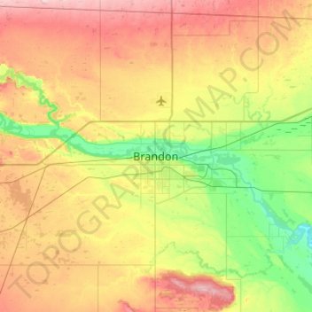
Name: Brandon topographic map, elevation, terrain.

Location: Brandon, Manitoba, R7A 2V8, Canada (49.69111 -100.12089 50.01111 -99.80089)

Average elevation: 1,342 ft

Minimum elevation: 1,135 ft

Maximum elevation: 1,617 ft

Other topographic maps

Click on a map to view its topography, its elevation and its terrain.

Brandon

Canada > Manitoba > Brandon

Average elevation: 1,289 ft

Gear up for your next adventure:

🏕️Family Camping Gear - Essentials for group camping trips
🏫Relief Map Kits - Hands-on tools for teaching landforms and elevation
🦶Hiking Gaiters - Keep debris and water out of your boots
📱Heavy-Duty Phone Cases - Drop-proof and waterproof protection for outdoor navigation
🧢Sun Protection Hats - Wide-brimmed and UPF-rated hats for high-altitude sun safety

As an Amazon Associate, this site earns from qualifying purchases at no extra cost to you.