Geolocate

Brandon topographic map

Click on the map to display elevation.

About this map

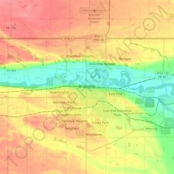
Name: Brandon topographic map, elevation, terrain.

Location: Brandon, Manitoba, Canada (49.81106 -100.00764 49.88953 -99.80605)

Average elevation: 1,289 ft

Minimum elevation: 1,165 ft

Maximum elevation: 1,391 ft

Other topographic maps

Click on a map to view its topography, its elevation and its terrain.

Brandon

Canada > Manitoba > Brandon

Average elevation: 1,342 ft

Gear up for your next adventure:

🧭Hiking Compass - Precision compass for reliable navigation in the wilderness
🎒Gear Packing Cubes - Organize your backpack efficiently
🔌Solar Panel Charger - Charge gear sustainably outdoors
📚Navigation Handbooks - Master the art of reading topographic maps and using a compass
🔌USB Car Charger - Car charger for on‑the‑go power needs

As an Amazon Associate, this site earns from qualifying purchases at no extra cost to you.