
Make a donation
Gear up for your next adventure:
As an Amazon Associate, this site earns from qualifying purchases at no extra cost to you.
Dokis Island topographic map
Click on the map to display elevation.
Make a donation
Gear up for your next adventure:
As an Amazon Associate, this site earns from qualifying purchases at no extra cost to you.
About this map
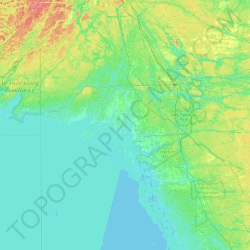
Name: Dokis Island topographic map, elevation, terrain.
Average elevation: 643 ft
Minimum elevation: 564 ft
Maximum elevation: 994 ft
Make a donation
Gear up for your next adventure:
As an Amazon Associate, this site earns from qualifying purchases at no extra cost to you.
Other topographic maps
Click on a map to view its topography, its elevation and its terrain.
Magnetawan River
Canada > Ontario > Parry Sound District > Unorganized Centre Parry Sound
Average elevation: 650 ft
Pickerel River
Canada > Ontario > Parry Sound District > Unorganized Centre Parry Sound
Average elevation: 656 ft
Harris Lake
Canada > Ontario > Parry Sound District > Unorganized Centre Parry Sound
Average elevation: 686 ft
Ferguson Island
Canada > Ontario > Parry Sound District > Unorganized Centre Parry Sound
Average elevation: 676 ft
Make a donation
Gear up for your next adventure:
As an Amazon Associate, this site earns from qualifying purchases at no extra cost to you.
Cole Lake
Canada > Ontario > Parry Sound District > Unorganized Centre Parry Sound
Average elevation: 709 ft
Grundy Lake Provincial Park
Canada > Ontario > Parry Sound District > Unorganized Centre Parry Sound
Average elevation: 646 ft
Key River
Canada > Ontario > Parry Sound District > Unorganized Centre Parry Sound
Average elevation: 636 ft
Culin Lake
Canada > Ontario > Parry Sound District > Unorganized Centre Parry Sound > Arnstein
Average elevation: 755 ft
Make a donation
Gear up for your next adventure:
As an Amazon Associate, this site earns from qualifying purchases at no extra cost to you.
Bob's Lake
Canada > Ontario > Parry Sound District > Unorganized Centre Parry Sound
Average elevation: 837 ft
Spring Lake
Canada > Ontario > Parry Sound District > Unorganized Centre Parry Sound
Average elevation: 1,040 ft
Restoule Lake
Canada > Ontario > Parry Sound District > Unorganized Centre Parry Sound
Average elevation: 804 ft
Key River
Canada > Ontario > Parry Sound District > Unorganized Centre Parry Sound
Average elevation: 633 ft
Make a donation
Gear up for your next adventure:
As an Amazon Associate, this site earns from qualifying purchases at no extra cost to you.