
Make a donation
Gear up for your next adventure:
As an Amazon Associate, this site earns from qualifying purchases at no extra cost to you.
Cole Lake topographic map
Click on the map to display elevation.
Make a donation
Gear up for your next adventure:
As an Amazon Associate, this site earns from qualifying purchases at no extra cost to you.
About this map
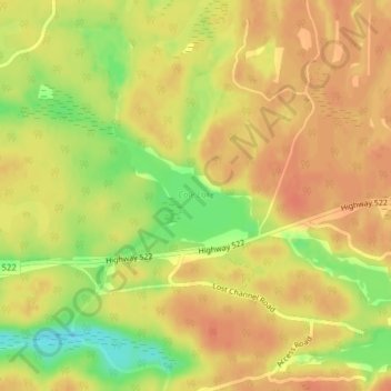
Name: Cole Lake topographic map, elevation, terrain.
Average elevation: 709 ft
Minimum elevation: 610 ft
Maximum elevation: 751 ft
Make a donation
Gear up for your next adventure:
As an Amazon Associate, this site earns from qualifying purchases at no extra cost to you.
Other topographic maps
Click on a map to view its topography, its elevation and its terrain.
Whistler Bay
Canada > Ontario > Parry Sound District > Unorganized Centre Parry Sound
Average elevation: 584 ft
Dokis Island
Canada > Ontario > Parry Sound District > Unorganized Centre Parry Sound
Average elevation: 643 ft
Port Loring
Canada > Ontario > Parry Sound District > Unorganized Centre Parry Sound
Average elevation: 745 ft
Restoule
Canada > Ontario > Parry Sound District > Unorganized Centre Parry Sound
Average elevation: 778 ft
Make a donation
Gear up for your next adventure:
As an Amazon Associate, this site earns from qualifying purchases at no extra cost to you.
Dollars Lake
Canada > Ontario > Parry Sound District > Unorganized Centre Parry Sound
Average elevation: 705 ft
Stormy Lake
Canada > Ontario > Parry Sound District > Unorganized Centre Parry Sound
Average elevation: 745 ft
Arnstein
Canada > Ontario > Parry Sound District > Unorganized Centre Parry Sound
Average elevation: 764 ft
Harris Lake
Canada > Ontario > Parry Sound District > Unorganized Centre Parry Sound
Average elevation: 686 ft
Make a donation
Gear up for your next adventure:
As an Amazon Associate, this site earns from qualifying purchases at no extra cost to you.
Grundy Lake Provincial Park
Canada > Ontario > Parry Sound District > Unorganized Centre Parry Sound
Average elevation: 646 ft
Bosworth Island
Canada > Ontario > Parry Sound District > Unorganized Centre Parry Sound
Average elevation: 735 ft
Spring Lake
Canada > Ontario > Parry Sound District > Unorganized Centre Parry Sound
Average elevation: 1,040 ft
Memesagamesing Lake Dam
Canada > Ontario > Parry Sound District > Unorganized Centre Parry Sound
Average elevation: 745 ft
Make a donation
Gear up for your next adventure:
As an Amazon Associate, this site earns from qualifying purchases at no extra cost to you.
Dollars Lake
Canada > Ontario > Parry Sound District > Unorganized Centre Parry Sound
Average elevation: 705 ft
Jack's Ridge
Canada > Ontario > Parry Sound District > Unorganized Centre Parry Sound
Average elevation: 833 ft
Restoule Lake
Canada > Ontario > Parry Sound District > Unorganized Centre Parry Sound
Average elevation: 804 ft
Smith Bay
Canada > Ontario > Parry Sound District > Unorganized Centre Parry Sound
Average elevation: 712 ft
Make a donation
Gear up for your next adventure:
As an Amazon Associate, this site earns from qualifying purchases at no extra cost to you.
Recollet Falls
Canada > Ontario > Parry Sound District > Unorganized Centre Parry Sound
Average elevation: 676 ft
Loring
Canada > Ontario > Parry Sound District > Unorganized Centre Parry Sound
Average elevation: 791 ft
Key Harbour
Canada > Ontario > Parry Sound District > Unorganized Centre Parry Sound
Average elevation: 584 ft
Clear Lake
Canada > Ontario > Parry Sound District > Unorganized Centre Parry Sound
Average elevation: 728 ft
Make a donation
Gear up for your next adventure:
As an Amazon Associate, this site earns from qualifying purchases at no extra cost to you.
Magee Island
Canada > Ontario > Parry Sound District > Unorganized Centre Parry Sound
Average elevation: 643 ft
Rye
Canada > Ontario > Parry Sound District > Unorganized Centre Parry Sound
Average elevation: 1,129 ft
Jack's Ridge
Canada > Ontario > Parry Sound District > Unorganized Centre Parry Sound
Average elevation: 833 ft
Jack's Ridge
Canada > Ontario > Parry Sound District > Unorganized Centre Parry Sound
Average elevation: 833 ft
Make a donation
Gear up for your next adventure:
As an Amazon Associate, this site earns from qualifying purchases at no extra cost to you.