
McGuire Reservoir topographic map
Interactive map
Click on the map to display elevation.
About this map
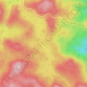
Name: McGuire Reservoir topographic map, elevation, terrain.
Location: McGuire Reservoir, Yamhill County, Oregon, United States (45.28610 -123.41014 45.30938 -123.39248)
Average elevation: 1,909 ft
Minimum elevation: 1,296 ft
Maximum elevation: 2,238 ft
Other topographic maps
Click on a map to view its topography, its elevation and its terrain.
Newberg
United States > Oregon > Yamhill County
Newberg, Yamhill County, Oregon, United States
Average elevation: 200 ft
McMinnville
United States > Oregon > Yamhill County
McMinnville, Yamhill County, Oregon, 97128, United States
Average elevation: 164 ft
Sheridan
United States > Oregon > Yamhill County
Sheridan, Yamhill County, Oregon, United States
Average elevation: 279 ft
Lafayette
United States > Oregon > Yamhill County
Lafayette, Yamhill County, Oregon, 97127, United States
Average elevation: 171 ft
Bald Peak State Scenic Viewpoint
United States > Oregon > Yamhill County
Bald Peak State Scenic Viewpoint, Southwest Bald Peak Road, Yamhill County, Oregon, United States
Average elevation: 1,096 ft
Carlton
United States > Oregon > Yamhill County
Carlton, Yamhill County, Oregon, 97111, United States
Average elevation: 167 ft
Amity
United States > Oregon > Yamhill County
Amity, Yamhill County, Oregon, United States
Average elevation: 167 ft
Dayton
United States > Oregon > Yamhill County
Dayton, Yamhill County, Oregon, United States
Average elevation: 141 ft
Dundee
United States > Oregon > Yamhill County
Dundee, Yamhill County, Oregon, 97115, United States
Average elevation: 226 ft
Willamina
United States > Oregon > Yamhill County > Willamina
Willamina, Yamhill County, Oregon, United States
Average elevation: 305 ft
Yamhill
United States > Oregon > Yamhill County > Yamhill
Yamhill, Yamhill County, Oregon, United States
Average elevation: 180 ft
Tetons
United States > Oregon > Yamhill County
Tetons, Yamhill County, Oregon, United States
Average elevation: 1,332 ft