
Bald Peak State Scenic Viewpoint topographic map
Interactive map
Click on the map to display elevation.
About this map
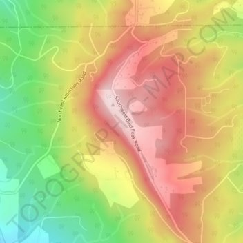
Name: Bald Peak State Scenic Viewpoint topographic map, elevation, terrain.
Average elevation: 1,096 ft
Minimum elevation: 423 ft
Maximum elevation: 1,650 ft
Bald Peak is on top of the Chehalem Mountains at an elevation of 1,629 feet (497 m) above sea level, the highest point in the mountain range. The closest community to the 26-acre (11 ha) park is Laurelwood, Oregon, with the park generally situated between the cities of Hillsboro to the north and Newberg to the south near the county boundary line between Yamhill and Washington counties. At the park are restrooms, picnic tables, parking, a trail, a forest with Douglas fir trees, but no drinking water. In clear weather, the park offers views of Mount Hood, Mount St. Helens, Mount Jefferson, Mount Adams, and Mount Rainier. The viewpoint also gives panoramas of the Tualatin Valley to the north of the park and the Yamhill Valley to the south, with both valleys being parts of the larger Willamette Valley.
Other topographic maps
Click on a map to view its topography, its elevation and its terrain.
McMinnville
United States > Oregon > Yamhill County
McMinnville, Yamhill County, Oregon, 97128, United States
Average elevation: 164 ft
Newberg
United States > Oregon > Yamhill County
Newberg, Yamhill County, Oregon, United States
Average elevation: 200 ft
Sheridan
United States > Oregon > Yamhill County
Sheridan, Yamhill County, Oregon, United States
Average elevation: 279 ft
Lafayette
United States > Oregon > Yamhill County
Lafayette, Yamhill County, Oregon, 97127, United States
Average elevation: 171 ft
McGuire Reservoir
United States > Oregon > Yamhill County
McGuire Reservoir, Yamhill County, Oregon, United States
Average elevation: 1,909 ft
Carlton
United States > Oregon > Yamhill County
Carlton, Yamhill County, Oregon, 97111, United States
Average elevation: 167 ft
Amity
United States > Oregon > Yamhill County
Amity, Yamhill County, Oregon, United States
Average elevation: 167 ft
Dayton
United States > Oregon > Yamhill County
Dayton, Yamhill County, Oregon, United States
Average elevation: 141 ft
Dundee
United States > Oregon > Yamhill County
Dundee, Yamhill County, Oregon, 97115, United States
Average elevation: 226 ft
Willamina
United States > Oregon > Yamhill County > Willamina
Willamina, Yamhill County, Oregon, United States
Average elevation: 305 ft
Yamhill
United States > Oregon > Yamhill County > Yamhill
Yamhill, Yamhill County, Oregon, United States
Average elevation: 180 ft
Tetons
United States > Oregon > Yamhill County
Tetons, Yamhill County, Oregon, United States
Average elevation: 1,332 ft