
Morborne topographic map
Click on the map to display elevation.
About this map
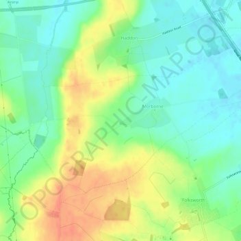
Name: Morborne topographic map, elevation, terrain.
Average elevation: 128 ft
Minimum elevation: 66 ft
Maximum elevation: 213 ft
Other topographic maps
Click on a map to view its topography, its elevation and its terrain.
Green End
United Kingdom > England > Cambridgeshire > Huntingdonshire > Great Stukeley
Average elevation: 105 ft
Hinchingbrooke Country Park
United Kingdom > England > Cambridgeshire > Huntingdonshire > Huntingdon > Brampton
Average elevation: 52 ft
Huntingdon Castle
United Kingdom > England > Cambridgeshire > Huntingdonshire > Huntingdon > Hartford
Average elevation: 46 ft
Washingley
United Kingdom > England > Cambridgeshire > Huntingdonshire > Folksworth
Average elevation: 157 ft
Holywell
United Kingdom > England > Cambridgeshire > Huntingdonshire > Holywell
Average elevation: 23 ft
Hartford Marina
United Kingdom > England > Cambridgeshire > Huntingdonshire > Wyton
Average elevation: 46 ft
Leighton Bromswold
United Kingdom > England > Cambridgeshire > Huntingdonshire
Average elevation: 161 ft
Keyston
United Kingdom > England > Cambridgeshire > Huntingdonshire > Keyston
Average elevation: 203 ft
Mill Pool
United Kingdom > England > Cambridgeshire > Huntingdonshire > Huntingdon
Average elevation: 46 ft