
Make a donation
Gear up for your next adventure:
As an Amazon Associate, this site earns from qualifying purchases at no extra cost to you.
Sheen Lake topographic map
Click on the map to display elevation.
Make a donation
Gear up for your next adventure:
As an Amazon Associate, this site earns from qualifying purchases at no extra cost to you.
About this map
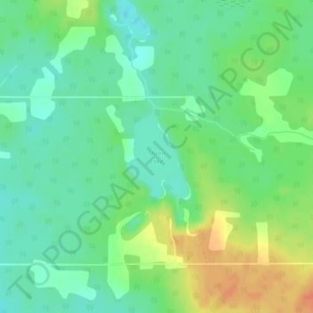
Name: Sheen Lake topographic map, elevation, terrain.
Average elevation: 925 ft
Minimum elevation: 873 ft
Maximum elevation: 1,010 ft
Make a donation
Gear up for your next adventure:
As an Amazon Associate, this site earns from qualifying purchases at no extra cost to you.
Other topographic maps
Click on a map to view its topography, its elevation and its terrain.
Nipin Lake
Canada > Ontario > Cochrane District > Unorganized North Cochrane
Average elevation: 863 ft
Ghost Lake;Pearce Creek
Canada > Ontario > Cochrane District > Unorganized North Cochrane
Average elevation: 699 ft
Make a donation
Gear up for your next adventure:
As an Amazon Associate, this site earns from qualifying purchases at no extra cost to you.
The Canyon
Canada > Ontario > Cochrane District > Unorganized North Cochrane
Average elevation: 827 ft