Geolocate

Carvalhal topographic map

Click on the map to display elevation.

About this map

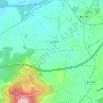
Name: Carvalhal topographic map, elevation, terrain.

Location: Carvalhal, Barcelos, Braga, 4755-101, Portugal (41.49732 -8.64564 41.51818 -8.62728)

Average elevation: 246 ft

Minimum elevation: 0 ft

Maximum elevation: 955 ft

Other topographic maps

Click on a map to view its topography, its elevation and its terrain.

Silveiros

Portugal > Braga > Barcelos

Average elevation: 446 ft

Fonte Coberta

Portugal > Braga > Barcelos

Average elevation: 384 ft

Monte do Facho

Portugal > Braga > Barcelos > Roriz

Average elevation: 397 ft

Vila Cova

Portugal > Braga > Barcelos

Average elevation: 322 ft

Feitos

Portugal > Braga > Barcelos

Average elevation: 850 ft

Milhazes

Portugal > Braga > Barcelos

Average elevation: 272 ft

Vilar do Monte

Portugal > Braga > Barcelos

Average elevation: 541 ft

Gonçalo

Portugal > Braga > Barcelos

Average elevation: 1,138 ft

Franqueira

Portugal > Braga > Barcelos

Average elevation: 479 ft

Martim de Além

Portugal > Braga > Barcelos > Martim

Average elevation: 440 ft

Durrães

Portugal > Braga > Barcelos

Average elevation: 433 ft

Gamil

Portugal > Braga > Barcelos

Average elevation: 223 ft

Gear up for your next adventure:

🗺️Topographic Maps - Detailed topo maps for hiking, exploring and outdoor navigation
🧣Hiking Neck Gaiter - Multi‑use neck protection for outdoor weather
🔭Compact Binoculars - HD vision for scouting terrain and identifying distant landmarks
🧺Microfiber Travel Towels - Compact and fast-drying towels for trail use
🔊Portable Camp Speaker - Music and alerts at camp

As an Amazon Associate, this site earns from qualifying purchases at no extra cost to you.