
Make a donation
Gear up for your next adventure:
As an Amazon Associate, this site earns from qualifying purchases at no extra cost to you.
Bays Mountain topographic map
Click on the map to display elevation.
Make a donation
Gear up for your next adventure:
As an Amazon Associate, this site earns from qualifying purchases at no extra cost to you.
Bays Mountain
The southern segment of Bays Mountain is relatively low in elevation (up to about 1,300 feet (396.2 m)). In some places it essentially merges with the surrounding plains, especially where it is bisected by the French Broad River and the Nolichucky River. The northern segment of Bays Mountain reaches higher elevations, averaging above 2,000 feet (609.6 m) with peaks reaching up to 3,000 feet (914.4 m). It is not a single ridge but rather a series of closely related ridges, some of which have names of their own (e.g., Fodderstack, Lost, Stone, Browns). The highest peak is Chimneytop Mountain (3,117 feet (950.1 m)), a spur ridge south of the main Bays Mountain ridge.
Make a donation
Gear up for your next adventure:
As an Amazon Associate, this site earns from qualifying purchases at no extra cost to you.
About this map
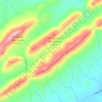
Name: Bays Mountain topographic map, elevation, terrain.
Average elevation: 1,375 ft
Minimum elevation: 1,142 ft
Maximum elevation: 1,706 ft
Hawkins County trails, hiking, mountain biking, running and outdoor activities
Make a donation
Gear up for your next adventure:
As an Amazon Associate, this site earns from qualifying purchases at no extra cost to you.
Other topographic maps
Click on a map to view its topography, its elevation and its terrain.
Make a donation
Gear up for your next adventure:
As an Amazon Associate, this site earns from qualifying purchases at no extra cost to you.
Make a donation
Gear up for your next adventure:
As an Amazon Associate, this site earns from qualifying purchases at no extra cost to you.
Greenland
United States > Tennessee > Hawkins County > Church Hill > Greenland
Average elevation: 1,243 ft