Geolocate

Flowery Branch topographic map

Click on the map to display elevation.

About this map
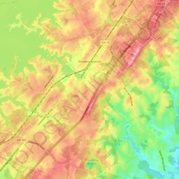
Name: Flowery Branch topographic map, elevation, terrain.

Location: Flowery Branch, Hall County, Georgia, 30542, United States (34.12683 -83.95920 34.21538 -83.88169)

Average elevation: 1,125 ft

Minimum elevation: 850 ft

Maximum elevation: 1,352 ft

Hall County trails, hiking, mountain biking, running and outdoor activities

Other topographic maps

Click on a map to view its topography, its elevation and its terrain.
Aqualand Park

United States > Georgia > Hall County

Average elevation: 1,076 ft

Candler

United States > Georgia > Hall County

Average elevation: 1,027 ft

Brookton

United States > Georgia > Hall County > Brookton

Average elevation: 1,319 ft

North Forest

United States > Georgia > Hall County > North Forest

Average elevation: 1,207 ft

Waverly Way

United States > Georgia > Hall County

Average elevation: 1,168 ft

Squirrel Creek

United States > Georgia > Hall County

Average elevation: 1,175 ft

Hidden Acres

United States > Georgia > Hall County

Average elevation: 1,168 ft

Bolman Estates

United States > Georgia > Hall County

Average elevation: 1,030 ft

Alandale

United States > Georgia > Hall County

Average elevation: 1,053 ft

Don Carter State Park

United States > Georgia > Hall County

Average elevation: 1,161 ft

Gear up for your next adventure:

👖Convertible Hiking Pants - Versatile zip-off pants for changing altitudes and temperatures
🪓Survival Multi‑Tool - Versatile tool for camp and trail tasks
🪶Camp Gear Gift Set - Perfect gift bundle for outdoor fans
🔋Solar Power Banks - Keep your GPS and phone charged in remote wilderness areas
🔌Solar Panel Charger - Charge gear sustainably outdoors

As an Amazon Associate, this site earns from qualifying purchases at no extra cost to you.