
Make a donation
Gear up for your next adventure:
As an Amazon Associate, this site earns from qualifying purchases at no extra cost to you.
Eureka Springs topographic map
Click on the map to display elevation.
Make a donation
Gear up for your next adventure:
As an Amazon Associate, this site earns from qualifying purchases at no extra cost to you.
Eureka Springs
It is a tourist destination for its unique character as a Victorian resort, which first attracted visitors to use its then believed healing springs. The city has steep winding streets filled with Victorian-style cottages and manors. The historic commercial downtown of the city has an extensive streetscape of well-preserved Victorian buildings. The buildings are primarily constructed of local stone, built along limestone streets that curve around the hills, and rise and fall with the topography in a five-mile long loop. Some buildings have street-level entrances on more than one floor and other such oddities: the Basin Park Hotel has its front entrances on the floor below first, and a ground-level emergency exit in the back of the building on the fifth floor. The streets wind around the town, with few intersecting at right angles. There are no traffic lights.
Make a donation
Gear up for your next adventure:
As an Amazon Associate, this site earns from qualifying purchases at no extra cost to you.
About this map
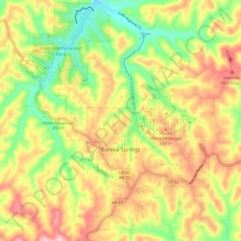
Name: Eureka Springs topographic map, elevation, terrain.
Average elevation: 1,348 ft
Minimum elevation: 984 ft
Maximum elevation: 1,722 ft
Carroll County trails, hiking, mountain biking, running and outdoor activities
Make a donation
Gear up for your next adventure:
As an Amazon Associate, this site earns from qualifying purchases at no extra cost to you.
Other topographic maps
Click on a map to view its topography, its elevation and its terrain.
Make a donation
Gear up for your next adventure:
As an Amazon Associate, this site earns from qualifying purchases at no extra cost to you.
Eureka Springs
United States > Arkansas > Carroll County > Eureka Springs
It is a tourist destination for its unique character as a Victorian resort village. The city has steep winding streets filled with Victorian-style cottages and manors. The historic commercial downtown of the city has an extensive streetscape of well-preserved Victorian buildings. The buildings are primarily…
Average elevation: 1,368 ft