
Holiday Island topographic map
Click on the map to display elevation.
About this map
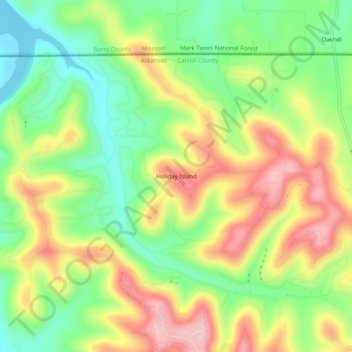
Name: Holiday Island topographic map, elevation, terrain.
Average elevation: 1,188 ft
Minimum elevation: 912 ft
Maximum elevation: 1,516 ft
Carroll County trails, hiking, mountain biking, running and outdoor activities
Other topographic maps
Click on a map to view its topography, its elevation and its terrain.
Eureka Springs
United States > Arkansas > Carroll County
It is a tourist destination for its unique character as a Victorian resort, which first attracted visitors to use its then-believed healing springs. The city has steep, winding streets filled with Victorian-style cottages and manors. The historic commercial downtown of the city has an extensive streetscape of…
Average elevation: 1,348 ft
Eureka Springs
United States > Arkansas > Carroll County
It is a tourist destination for its unique character as a Victorian resort, which first attracted visitors to use its then believed healing springs. The city has steep winding streets filled with Victorian-style cottages and manors. The historic commercial downtown of the city has an extensive streetscape of…
Average elevation: 1,348 ft
Eureka Springs
United States > Arkansas > Carroll County
It is a tourist destination for its unique character as a Victorian resort, which first attracted visitors to use its then-believed healing springs. The city has steep, winding streets filled with Victorian-style cottages and manors. The historic commercial downtown of the city has an extensive streetscape of…
Average elevation: 1,348 ft
Eureka Springs
United States > Arkansas > Carroll County
It is a tourist destination for its unique character as a Victorian resort, which first attracted visitors to use its then believed healing springs. The city has steep winding streets filled with Victorian-style cottages and manors. The historic commercial downtown of the city has an extensive streetscape of…
Average elevation: 1,348 ft
Eureka Springs
United States > Arkansas > Carroll County
It is a tourist destination for its unique character as a Victorian resort, which first attracted visitors to use its then-believed healing springs. The city has steep, winding streets filled with Victorian-style cottages and manors. The historic commercial downtown of the city has an extensive streetscape of…
Average elevation: 1,348 ft
Table Rock Lake
United States > Arkansas > Carroll County > Kimberling City
Average elevation: 1,093 ft