
Make a donation
Gear up for your next adventure:
As an Amazon Associate, this site earns from qualifying purchases at no extra cost to you.
Osage topographic map
Click on the map to display elevation.
Make a donation
Gear up for your next adventure:
As an Amazon Associate, this site earns from qualifying purchases at no extra cost to you.
About this map
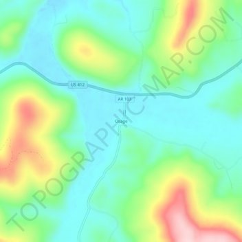
Name: Osage topographic map, elevation, terrain.
Location: Osage, Carroll County, Arkansas, United States (36.16257 -93.42463 36.20257 -93.38463)
Average elevation: 1,526 ft
Minimum elevation: 1,280 ft
Maximum elevation: 2,073 ft
Make a donation
Gear up for your next adventure:
As an Amazon Associate, this site earns from qualifying purchases at no extra cost to you.
Other topographic maps
Click on a map to view its topography, its elevation and its terrain.
Eureka Springs
United States > Arkansas > Carroll County
It is a tourist destination for its unique character as a Victorian resort, which first attracted visitors to use its then believed healing springs. The city has steep winding streets filled with Victorian-style cottages and manors. The historic commercial downtown of the city has an extensive streetscape of…
Average elevation: 1,348 ft
Make a donation
Gear up for your next adventure:
As an Amazon Associate, this site earns from qualifying purchases at no extra cost to you.
Eureka Springs
United States > Arkansas > Carroll County
It is a tourist destination for its unique character as a Victorian resort, which first attracted visitors to use its then believed healing springs. The city has steep winding streets filled with Victorian-style cottages and manors. The historic commercial downtown of the city has an extensive streetscape of…
Average elevation: 1,348 ft
Eureka Springs
United States > Arkansas > Carroll County
It is a tourist destination for its unique character as a Victorian resort, which first attracted visitors to use its then-believed healing springs. The city has steep, winding streets filled with Victorian-style cottages and manors. The historic commercial downtown of the city has an extensive streetscape of…
Average elevation: 1,348 ft
Eureka Springs
United States > Arkansas > Carroll County
It is a tourist destination for its unique character as a Victorian resort, which first attracted visitors to use its then believed healing springs. The city has steep winding streets filled with Victorian-style cottages and manors. The historic commercial downtown of the city has an extensive streetscape of…
Average elevation: 1,348 ft
Make a donation
Gear up for your next adventure:
As an Amazon Associate, this site earns from qualifying purchases at no extra cost to you.
Table Rock Lake
United States > Arkansas > Carroll County > Kimberling City
Average elevation: 1,093 ft