
Make a donation
Gear up for your next adventure:
As an Amazon Associate, this site earns from qualifying purchases at no extra cost to you.
Puerto Tejada topographic map
Click on the map to display elevation.
Make a donation
Gear up for your next adventure:
As an Amazon Associate, this site earns from qualifying purchases at no extra cost to you.
About this map
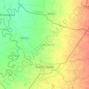
Name: Puerto Tejada topographic map, elevation, terrain.
Location: Puerto Tejada, Norte, Cauca, Colombia (3.19936 -76.49454 3.32909 -76.35175)
Average elevation: 3,169 ft
Minimum elevation: 3,104 ft
Maximum elevation: 3,238 ft
Make a donation
Gear up for your next adventure:
As an Amazon Associate, this site earns from qualifying purchases at no extra cost to you.
Other topographic maps
Click on a map to view its topography, its elevation and its terrain.
Reserva Natural de la Sociedad Civil El Palmichal
Average elevation: 8,451 ft
Make a donation
Gear up for your next adventure:
As an Amazon Associate, this site earns from qualifying purchases at no extra cost to you.
Make a donation
Gear up for your next adventure:
As an Amazon Associate, this site earns from qualifying purchases at no extra cost to you.