
Kahler topographic map
Click on the map to display elevation.
About this map
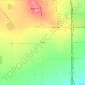
Name: Kahler topographic map, elevation, terrain.
Location: Kahler, Weld County, Colorado, United States (40.30832 -105.01859 40.34832 -104.97859)
Average elevation: 5,013 ft
Minimum elevation: 4,849 ft
Maximum elevation: 5,174 ft
Other topographic maps
Click on a map to view its topography, its elevation and its terrain.
Greeley
United States > Colorado > Weld County
Greeley experiences a semi-arid climate (Köppen BSk). High temperatures are generally around 90–95 °F (32 °C) in the summer and 40-45 °F (4 °C) in the winter, although significant variation occurs. The hottest days generally occur around the third week of July and the coldest in January. Nighttime lows…
Average elevation: 4,751 ft
Windsor
United States > Colorado > Weld County
Some days in the winter and spring can be warm and extremely dry, with Chinook winds often raising temperatures to near 70 °F (21 °C) in January and February, and sometimes to near 90 °F (32 °C) in April. Windsor's elevation and low year-round humidity means that nighttime low temperatures are practically…
Average elevation: 4,872 ft
Saint Vrain State Park
United States > Colorado > Weld County > Firestone
The land of St. Vrain State Park was originally home to Ute, Arapaho, and Cheyenne Native American tribes. Once claimed by Spain then France who sold it to the United States in 1803 as part of the Louisiana Purchase. Having just made the largest land purchase in the history of the nation, the government was…
Average elevation: 4,856 ft
Greeley
United States > Colorado > Weld County
Greeley experiences a semi-arid climate (Köppen BSk). High temperatures are generally around 90–95 °F (32 °C) in the summer and 40-45 °F (4 °C) in the winter, although significant variation occurs. The hottest days generally occur around the third week of July and the coldest in January. Nighttime lows…
Average elevation: 4,751 ft
Windsor
United States > Colorado > Weld County
Some days in the winter and spring can be warm and extremely dry, with Chinook winds often raising temperatures to near 70 °F (21 °C) in January and February, and sometimes to near 90 °F (32 °C) in April. Windsor's elevation and low year-round humidity means that nighttime low temperatures are practically…
Average elevation: 4,872 ft
Greeley
United States > Colorado > Weld County
Greeley experiences a semi-arid climate (Köppen BSk). High temperatures are generally around 90–95 °F (32 °C) in the summer and 40-45 °F (4 °C) in the winter, although significant variation occurs. The hottest days generally occur around the third week of July and the coldest in January. Nighttime lows…
Average elevation: 4,751 ft