
Western Macedonia topographic map
Interactive map
Click on the map to display elevation.
About this map
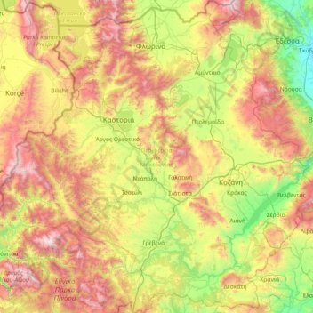
Name: Western Macedonia topographic map, elevation, terrain.
Location: Western Macedonia, Epirus and Western Macedonia, Greece (39.83036 20.77537 40.94346 22.19532)
Average elevation: 3,077 ft
Minimum elevation: 85 ft
Maximum elevation: 8,520 ft
Other topographic maps
Click on a map to view its topography, its elevation and its terrain.
Ioannina Regional Unit
Greece > Epirus and Western Macedonia
Ioannina Regional Unit, Epirus, Epirus and Western Macedonia, Greece
Average elevation: 2,756 ft
Βατερό
Greece > Epirus and Western Macedonia > Kozani Regional Unit
Βατερό, Municipality of Kozani, Kozani Regional Unit, Western Macedonia, Epirus and Western Macedonia, 501 00, Greece
Average elevation: 2,388 ft
North Tzoumerka Municipality
Greece > Epirus and Western Macedonia > Ioannina Regional Unit
North Tzoumerka Municipality, Ioannina Regional Unit, Epirus, Epirus and Western Macedonia, Greece
Average elevation: 3,248 ft
Παρακάλαμος
Greece > Epirus and Western Macedonia > Ioannina Regional Unit
Παρακάλαμος, Pogoni Municipality, Ioannina Regional Unit, Epirus, Epirus and Western Macedonia, 440 04, Greece
Average elevation: 1,365 ft
Πτελέα
Greece > Epirus and Western Macedonia > Kastoria Regional Unit
Πτελέα, Nestorio Municipality, Kastoria Regional Unit, Western Macedonia, Epirus and Western Macedonia, 520 51, Greece
Average elevation: 2,864 ft
Κήποι
Greece > Epirus and Western Macedonia > Ioannina Regional Unit
Κήποι, Zagori Municipality, Ioannina Regional Unit, Epirus, Epirus and Western Macedonia, 440 07, Greece
Average elevation: 2,858 ft
Samarina
Greece > Epirus and Western Macedonia > Grevena Regional Unit
Samarina, Municipality of Grevena, Grevena Regional Unit, Western Macedonia, Epirus and Western Macedonia, 510 32, Greece
Average elevation: 5,112 ft
Pisoderi
Greece > Epirus and Western Macedonia > Florina Regional Unit > Prespes Municipal Unit
Pisoderi, Prespes Municipal Unit, Prespes Municipality, Florina Regional Unit, Western Macedonia, Epirus and Western Macedonia, 530 76, Greece
Average elevation: 5,256 ft
Falakro (Vitsi)
Greece > Epirus and Western Macedonia > Florina Regional Unit > Prespes Municipal Unit
Falakro (Vitsi), Prespes Municipal Unit, Prespes Municipality, Florina Regional Unit, Western Macedonia, Epirus and Western Macedonia, Greece
Average elevation: 5,354 ft
Βασιλίτσα
Greece > Epirus and Western Macedonia > Ioannina Regional Unit
Βασιλίτσα, Konitsa Municipality, Ioannina Regional Unit, Epirus, Epirus and Western Macedonia, Greece
Average elevation: 6,201 ft
Louros Dam
Greece > Epirus and Western Macedonia > Preveza Regional Unit > Agios Georgios
Louros Dam, Agios Georgios, Ziros Municipality, Preveza Regional Unit, Epirus, Epirus and Western Macedonia, 482 00, Greece
Average elevation: 630 ft
Καστοριά
Greece > Epirus and Western Macedonia > Kastoria Regional Unit
Καστοριά, Municipality of Kastoria, Kastoria Regional Unit, Western Macedonia, Epirus and Western Macedonia, 521 00, Greece
Average elevation: 3,114 ft
Μέτσοβο
Greece > Epirus and Western Macedonia > Ioannina Regional Unit
Μέτσοβο, Metsovo Municipality, Ioannina Regional Unit, Epirus, Epirus and Western Macedonia, 442 00, Greece
Average elevation: 4,324 ft
Kefalovryso
Greece > Epirus and Western Macedonia > Thesprotia Regional Unit
Kefalovryso, Souli Municipality, Thesprotia Regional Unit, Epirus, Epirus and Western Macedonia, 462 00, Greece
Average elevation: 1,243 ft
Κοζάνη
Greece > Epirus and Western Macedonia > Kozani Regional Unit
Κοζάνη, Municipality of Kozani, Kozani Regional Unit, Western Macedonia, Epirus and Western Macedonia, 501 00, Greece
Average elevation: 2,513 ft
Ανάργυροι
Greece > Epirus and Western Macedonia > Ioannina Regional Unit
Ανάργυροι, Zitsa Municipality, Ioannina Regional Unit, Epirus, Epirus and Western Macedonia, 455 00, Greece
Average elevation: 2,142 ft
Μεσοποταμία
Greece > Epirus and Western Macedonia > Kastoria Regional Unit > Μεσοποταμία
Μεσοποταμία, Municipality of Kastoria, Kastoria Regional Unit, Western Macedonia, Epirus and Western Macedonia, 52050, Greece
Average elevation: 2,375 ft
Epirus
Greece > Epirus and Western Macedonia
Epirus, Epirus and Western Macedonia, Greece
Average elevation: 1,978 ft
Florina
Greece > Epirus and Western Macedonia > Florina Regional Unit
Florina, Municipality of Florina, Florina Regional Unit, Western Macedonia, Epirus and Western Macedonia, 531 00, Greece
Average elevation: 3,278 ft
Ambelia
Greece > Epirus and Western Macedonia > Arta Regional Unit > Ambelia
Ambelia, Arta Municipality, Arta Regional Unit, Epirus, Epirus and Western Macedonia, 48200, Greece
Average elevation: 682 ft
Ptolemaida
Greece > Epirus and Western Macedonia > Ptolemaida
Ptolemaida, Δήμος Εορδαίας, Kozani Regional Unit, Western Macedonia, Epirus and Western Macedonia, 50200, Greece
Average elevation: 2,041 ft
Zagori Municipality
Greece > Epirus and Western Macedonia
Zagori Municipality, Ioannina Regional Unit, Epirus, Epirus and Western Macedonia, Greece
Average elevation: 3,455 ft
Κόνιτσα
Greece > Epirus and Western Macedonia > Ioannina Regional Unit
Κόνιτσα, Konitsa Municipality, Ioannina Regional Unit, Epirus, Epirus and Western Macedonia, 441 00, Greece
Average elevation: 2,638 ft
Lithia
Greece > Epirus and Western Macedonia > Kastoria Regional Unit > Lithia
Lithia, Municipality of Kastoria, Kastoria Regional Unit, Western Macedonia, Epirus and Western Macedonia, 52052, Greece
Average elevation: 2,864 ft
Δήμος Κοζάνης
Greece > Epirus and Western Macedonia > Kozani Regional Unit
Δήμος Κοζάνης, Kozani Regional Unit, Western Macedonia, Epirus and Western Macedonia, Greece
Average elevation: 2,621 ft
Pramanta
Greece > Epirus and Western Macedonia > Ioannina Regional Unit > Pramanta
Pramanta, North Tzoumerka Municipality, Ioannina Regional Unit, Epirus, Epirus and Western Macedonia, 44001, Greece
Average elevation: 2,782 ft