
Make a donation
Gear up for your next adventure:
As an Amazon Associate, this site earns from qualifying purchases at no extra cost to you.
Zagori Municipality topographic map
Click on the map to display elevation.
Make a donation
Gear up for your next adventure:
As an Amazon Associate, this site earns from qualifying purchases at no extra cost to you.
About this map
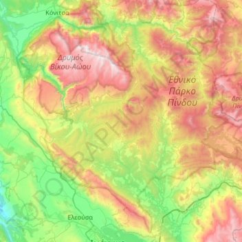
Name: Zagori Municipality topographic map, elevation, terrain.
Average elevation: 3,455 ft
Minimum elevation: 558 ft
Maximum elevation: 8,104 ft
Make a donation
Gear up for your next adventure:
As an Amazon Associate, this site earns from qualifying purchases at no extra cost to you.
Other topographic maps
Click on a map to view its topography, its elevation and its terrain.
Σέρβια
Greece > Epirus and Western Macedonia > Kozani Regional Unit > Servia Municipal Unit
The Philharmonic band of the town, established in 1928, is run by the "Morphotikos Omilos Servion", which is the main Cultural Society of the town. It organises a wide range of cultural events and supports teaching classes for children and adults in painting, dance, choir, and chess. Hang gliding is prominent…
Average elevation: 1,854 ft
Φαράγγι Βίκου
Greece > Epirus and Western Macedonia > Ioannina Regional Unit
Average elevation: 3,576 ft
Make a donation
Gear up for your next adventure:
As an Amazon Associate, this site earns from qualifying purchases at no extra cost to you.
Χρυσογιάλι
Greece > Epirus and Western Macedonia > Preveza Regional Unit > Parga
Average elevation: 423 ft
Make a donation
Gear up for your next adventure:
As an Amazon Associate, this site earns from qualifying purchases at no extra cost to you.
Make a donation
Gear up for your next adventure:
As an Amazon Associate, this site earns from qualifying purchases at no extra cost to you.
Make a donation
Gear up for your next adventure:
As an Amazon Associate, this site earns from qualifying purchases at no extra cost to you.
Φαράγγι Βίκου
Greece > Epirus and Western Macedonia > Ioannina Regional Unit
Average elevation: 3,802 ft
Ioannina
Greece > Epirus and Western Macedonia > Ioannina Regional Unit
According to the 2021 census, the city population was 64,896 while the municipality had 113,978 inhabitants. It lies at an elevation of approximately 500 metres (1,640 feet) above sea level, on the western shore of Lake Pamvotis (Παμβώτις). Ioannina is located 410 km (255 mi) northwest of Athens, 260…
Average elevation: 2,375 ft
Make a donation
Gear up for your next adventure:
As an Amazon Associate, this site earns from qualifying purchases at no extra cost to you.
Κατσικάς
Greece > Epirus and Western Macedonia > Ioannina Regional Unit > Pamvotida Municipal Unit
Average elevation: 1,621 ft
Make a donation
Gear up for your next adventure:
As an Amazon Associate, this site earns from qualifying purchases at no extra cost to you.
Nymfeo
Greece > Epirus and Western Macedonia > Florina Regional Unit
Nymfaio is a mountain village, situated at 1350 m elevation in the densely forested Verno mountains. It is 3 km north of Sklithro, 5 km west of Aetos, 16 km west of Amyntaio and 17 km southeast of Florina.
Average elevation: 3,983 ft
Ioannina
Greece > Epirus and Western Macedonia > Ioannina Regional Unit
Ioannina (Greek: Ιωάννινα Ioánnina [i.oˈa.ni.na] (listen)), often called Yannena (Γιάννενα Yánnena [ˈʝa.ne.na]) within Greece, is the capital and largest city of the Ioannina regional unit and of Epirus, an administrative region in north-western Greece. According to the 2011 census, the…
Average elevation: 2,375 ft
Make a donation
Gear up for your next adventure:
As an Amazon Associate, this site earns from qualifying purchases at no extra cost to you.
Πανεπιστημιούπολη
Greece > Epirus and Western Macedonia > Ioannina Regional Unit > Ioannina > Νεοχωρόπουλο
Average elevation: 1,765 ft
Metamorfosi
Greece > Epirus and Western Macedonia > Kastoria Regional Unit
Average elevation: 2,497 ft
Make a donation
Gear up for your next adventure:
As an Amazon Associate, this site earns from qualifying purchases at no extra cost to you.
Ανάληψη
Greece > Epirus and Western Macedonia > Florina Regional Unit > Amyndeo
Average elevation: 1,939 ft
Psarades
Greece > Epirus and Western Macedonia > Florina Regional Unit > Prespes Municipal Unit
Average elevation: 3,015 ft
Make a donation
Gear up for your next adventure:
As an Amazon Associate, this site earns from qualifying purchases at no extra cost to you.
Μικρό Πάπιγκο
Greece > Epirus and Western Macedonia > Ioannina Regional Unit
Average elevation: 4,072 ft
Παρακάλαμος
Greece > Epirus and Western Macedonia > Ioannina Regional Unit
Average elevation: 1,365 ft
Make a donation
Gear up for your next adventure:
As an Amazon Associate, this site earns from qualifying purchases at no extra cost to you.
Κήποι
Greece > Epirus and Western Macedonia > Ioannina Regional Unit
Kipoi (Greek: Κήποι, before 1928: Μπάγια – Bagia) is a village in the region of Zagori. It belongs to the municipal unit of Tymfi, Ioannina regional unit, Greece. The Greek name derives from the many gardens in the surrounding areas (Greek Κήποι=Gardens). The name "Bagia" is Slavic and means…
Average elevation: 2,858 ft
Make a donation
Gear up for your next adventure:
As an Amazon Associate, this site earns from qualifying purchases at no extra cost to you.
Samarina
Greece > Epirus and Western Macedonia > Grevena Regional Unit
Samarina is located on an eastern spur of Mount Smolikas, the highest of the Pindus range and the second-highest mountain in all of Greece. At an altitude of 1380–1515 meters (4528' to 4970'), it is considered one of the highest villages in Greece and also one of the highest in the Balkans; its height puts…
Average elevation: 5,112 ft
Pisoderi
Greece > Epirus and Western Macedonia > Florina Regional Unit > Prespes Municipal Unit
Average elevation: 5,256 ft
Falakro (Vitsi)
Greece > Epirus and Western Macedonia > Florina Regional Unit > Prespes Municipal Unit
Average elevation: 5,354 ft
Make a donation
Gear up for your next adventure:
As an Amazon Associate, this site earns from qualifying purchases at no extra cost to you.
Florina
Greece > Epirus and Western Macedonia > Florina Regional Unit
Florina is one of the coldest towns in Greece, because of its elevation and geographic position. Heavy snowfalls, thick fog and below-freezing temperatures are common during the winter months, while the summers are mild. Under the Köppen climate classification, Florina has a humid subtropical climate (Cfa)…
Average elevation: 3,278 ft
Ambelia
Greece > Epirus and Western Macedonia > Arta Regional Unit > Ambelia
Average elevation: 682 ft
Make a donation
Gear up for your next adventure:
As an Amazon Associate, this site earns from qualifying purchases at no extra cost to you.
Kefalovryso
Greece > Epirus and Western Macedonia > Thesprotia Regional Unit
Average elevation: 1,243 ft
Make a donation
Gear up for your next adventure:
As an Amazon Associate, this site earns from qualifying purchases at no extra cost to you.