Geolocate

Camden Point topographic map

Click on the map to display elevation.

About this map

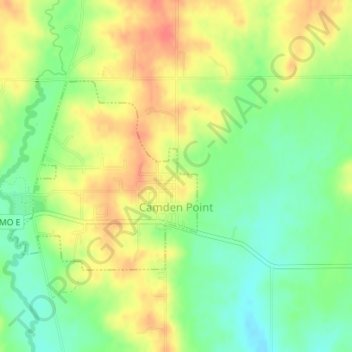
Name: Camden Point topographic map, elevation, terrain.

Location: Camden Point, Platte County, Missouri, 64018, United States (39.44792 -94.75811 39.46242 -94.73951)

Average elevation: 915 ft

Minimum elevation: 830 ft

Maximum elevation: 1,001 ft

Platte County trails, hiking, mountain biking, running and outdoor activities

Other topographic maps

Click on a map to view its topography, its elevation and its terrain.

Sadler

United States > Missouri > Platte County

Average elevation: 827 ft

Waldron

United States > Missouri > Platte County

Average elevation: 830 ft

Parkville

United States > Missouri > Platte County > Parkville > Parkville

Average elevation: 856 ft

Gear up for your next adventure:

🎒Trekking Poles - Sturdy poles for balance and stability on rough terrain
🍳Camping Cook Set - Complete cookware for outdoor meals
🛶Inflatable Kayak - Portable kayak for rivers, lakes, and expeditions
🏫Relief Map Kits - Hands-on tools for teaching landforms and elevation
🥘Titanium Cookware - Durable, featherlight pots and pans for backpacking

As an Amazon Associate, this site earns from qualifying purchases at no extra cost to you.