
Make a donation
Gear up for your next adventure:
As an Amazon Associate, this site earns from qualifying purchases at no extra cost to you.
Malaga Cove topographic map
Click on the map to display elevation.
Make a donation
Gear up for your next adventure:
As an Amazon Associate, this site earns from qualifying purchases at no extra cost to you.
About this map
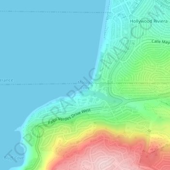
Name: Malaga Cove topographic map, elevation, terrain.
Average elevation: 213 ft
Minimum elevation: 0 ft
Maximum elevation: 902 ft
Los Angeles County trails, hiking, mountain biking, running and outdoor activities
Make a donation
Gear up for your next adventure:
As an Amazon Associate, this site earns from qualifying purchases at no extra cost to you.
Other topographic maps
Click on a map to view its topography, its elevation and its terrain.
West Hills Neighborhood Council District
United States > California > Los Angeles County > Los Angeles
Average elevation: 1,047 ft
Hollywood Hills
United States > California > Los Angeles County > Los Angeles
Average elevation: 794 ft
Pacific Palisades
United States > California > Los Angeles County > Los Angeles
Pacific Palisades was formally founded in 1921 by a Methodist organization, and in the years that followed became a refuge for Jewish artists and intellectuals fleeing the Holocaust. The Palisades would later be sought after by celebrities and other high-profile individuals seeking privacy. It is known for its…
Average elevation: 643 ft
Santa Ynez Reservoir
United States > California > Los Angeles County > Los Angeles
Average elevation: 1,007 ft
Make a donation
Gear up for your next adventure:
As an Amazon Associate, this site earns from qualifying purchases at no extra cost to you.
Los Angeles City Council District 5
United States > California > Los Angeles County > Los Angeles
Average elevation: 430 ft
Make a donation
Gear up for your next adventure:
As an Amazon Associate, this site earns from qualifying purchases at no extra cost to you.
Arleta Neighborhood Council District
United States > California > Los Angeles County > Los Angeles
Average elevation: 899 ft
Santa Susana Mountains
United States > California > Los Angeles County > Unincorporated Chatsworth
Average elevation: 1,791 ft
San Gabriel River
United States > California > Los Angeles County > Pico Rivera
Average elevation: 292 ft
Make a donation
Gear up for your next adventure:
As an Amazon Associate, this site earns from qualifying purchases at no extra cost to you.
Make a donation
Gear up for your next adventure:
As an Amazon Associate, this site earns from qualifying purchases at no extra cost to you.
Make a donation
Gear up for your next adventure:
As an Amazon Associate, this site earns from qualifying purchases at no extra cost to you.
Los Angeles City Council District 7
United States > California > Los Angeles County > Los Angeles
Average elevation: 1,680 ft
Angeles National Forest
United States > California > Los Angeles County
The Angeles National Forest manages the habitats, flora and fauna ecosystems, and watersheds. Some of the rivers with watersheds within its boundaries provide valuable non-groundwater recharge water for Southern California. The existing protected and restored native vegetation absorb and slow surface runoff of…
Average elevation: 2,566 ft
Make a donation
Gear up for your next adventure:
As an Amazon Associate, this site earns from qualifying purchases at no extra cost to you.
Make a donation
Gear up for your next adventure:
As an Amazon Associate, this site earns from qualifying purchases at no extra cost to you.
Make a donation
Gear up for your next adventure:
As an Amazon Associate, this site earns from qualifying purchases at no extra cost to you.
Avocado Heights
United States > California > Los Angeles County > Avocado Heights
Average elevation: 367 ft
Make a donation
Gear up for your next adventure:
As an Amazon Associate, this site earns from qualifying purchases at no extra cost to you.
Los Angeles City Council District 6
United States > California > Los Angeles County > Los Angeles
Average elevation: 827 ft
Decker Canyon Camp
United States > California > Los Angeles County > Malibu
Average elevation: 1,263 ft
Make a donation
Gear up for your next adventure:
As an Amazon Associate, this site earns from qualifying purchases at no extra cost to you.
Mount Wilson Observatory
United States > California > Los Angeles County > Mount Wilson
Average elevation: 4,662 ft
Runyon Canyon Park
United States > California > Los Angeles County > Los Angeles
Average elevation: 771 ft
Make a donation
Gear up for your next adventure:
As an Amazon Associate, this site earns from qualifying purchases at no extra cost to you.
Val Verde
United States > California > Los Angeles County
Val Verde is located in the San Martinez Chiquito Canyon in the southeastern foothills of the Topatopa Mountains at an elevation ranging from 1,250–1,400 feet (380–430 m). The canyon contains a creek with runs intermittently through the community. It is about 50 miles (80 km) northwest of the county seat…
Average elevation: 1,444 ft
East Naples Canal
United States > California > Los Angeles County > Long Beach
Average elevation: 10 ft
Make a donation
Gear up for your next adventure:
As an Amazon Associate, this site earns from qualifying purchases at no extra cost to you.
Los Angeles River
United States > California > Los Angeles County > Los Angeles
Average elevation: 797 ft
The Cobb Estate
United States > California > Los Angeles County > Altadena
Average elevation: 2,116 ft
Make a donation
Gear up for your next adventure:
As an Amazon Associate, this site earns from qualifying purchases at no extra cost to you.
Golden Shore Marine Biological Reserve
United States > California > Los Angeles County > Long Beach
Average elevation: 23 ft
Make a donation
Gear up for your next adventure:
As an Amazon Associate, this site earns from qualifying purchases at no extra cost to you.
Lake Elizabeth
United States > California > Los Angeles County
The lake, at 984 m (3,228 ft) in elevation, is within the Angeles National Forest. It is a natural perennial lake, but may dry up entirely during drought years. It is south of the western Antelope Valley.
Average elevation: 3,494 ft
Topanga County Beach
United States > California > Los Angeles County > Malibu
Average elevation: 174 ft
Make a donation
Gear up for your next adventure:
As an Amazon Associate, this site earns from qualifying purchases at no extra cost to you.
Topanga State Park
United States > California > Los Angeles County > Los Angeles
Average elevation: 1,093 ft
Edward Vincent Jr. Park
United States > California > Los Angeles County > Inglewood
Average elevation: 184 ft
Augustus F. Hawkins Natural Park
United States > California > Los Angeles County > Los Angeles
Average elevation: 180 ft
Make a donation
Gear up for your next adventure:
As an Amazon Associate, this site earns from qualifying purchases at no extra cost to you.
Maguire Gardens
United States > California > Los Angeles County > Los Angeles
Average elevation: 325 ft
La Puerta Sports Park
United States > California > Los Angeles County > Claremont
Average elevation: 1,545 ft
Whittier Narrows
United States > California > Los Angeles County > South El Monte
Average elevation: 246 ft
Make a donation
Gear up for your next adventure:
As an Amazon Associate, this site earns from qualifying purchases at no extra cost to you.
Stoneview Nature Center
United States > California > Los Angeles County > Culver City
Average elevation: 210 ft
Genesee Avenue Park
United States > California > Los Angeles County > Los Angeles
Average elevation: 108 ft
East Rancho Dominguez County Park
United States > California > Los Angeles County > East Compton
Average elevation: 72 ft