
Malaga Cove topographic map
Interactive map
Click on the map to display elevation.
About this map
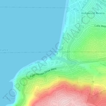
Name: Malaga Cove topographic map, elevation, terrain.
Average elevation: 213 ft
Minimum elevation: 0 ft
Maximum elevation: 902 ft
Other topographic maps
Click on a map to view its topography, its elevation and its terrain.
Los Angeles
United States > California > Los Angeles County
Los Angeles, California, United States
Average elevation: 791 ft
Torrance
United States > California > Los Angeles County
Torrance, Los Angeles County, California, United States
Average elevation: 151 ft
Hollywood Hills
United States > California > Los Angeles County > Los Angeles
Hollywood Hills, Los Angeles, Los Angeles County, California, United States
Average elevation: 794 ft
San Fernando Valley
United States > California > Los Angeles County > Los Angeles
San Fernando Valley, Los Angeles, Los Angeles County, California, 91406, United States
Average elevation: 1,627 ft
Griffith Park
United States > California > Los Angeles County > Los Angeles
Griffith Park, Los Angeles, Los Angeles County, CAL Fire Southern Region, California, United States
Average elevation: 725 ft
Whittier
United States > California > Los Angeles County
Whittier, Los Angeles County, California, United States
Average elevation: 377 ft
La Cañada Flintridge
United States > California > Los Angeles County
La Cañada Flintridge, Los Angeles County, California, 91011, United States
Average elevation: 1,657 ft
Altadena
United States > California > Los Angeles County
Altadena, Los Angeles County, California, 91001, United States
Average elevation: 1,709 ft
El Segundo
United States > California > Los Angeles County
El Segundo, Los Angeles County, California, 90245, United States
Average elevation: 66 ft
Claremont
United States > California > Los Angeles County
Claremont, Los Angeles County, California, 91711, United States
Average elevation: 1,535 ft
Sierra Madre
United States > California > Los Angeles County
Sierra Madre, Los Angeles County, California, 91024, United States
Average elevation: 1,184 ft
Castaic
United States > California > Los Angeles County
Castaic, Los Angeles County, California, 91384, United States
Average elevation: 1,447 ft
West Hills Neighborhood Council District
United States > California > Los Angeles County > Los Angeles
West Hills Neighborhood Council District, Los Angeles City Council District 12, Los Angeles, Los Angeles County, California, United States
Average elevation: 1,047 ft
Pacific Palisades
United States > California > Los Angeles County > Los Angeles
Pacific Palisades, Los Angeles, Los Angeles County, California, United States
Average elevation: 643 ft
San Pedro Hill
United States > California > Los Angeles County > Rancho Palos Verdes
San Pedro Hill, Rancho Palos Verdes, Los Angeles County, California, 90732, United States
Average elevation: 935 ft
Vincent
United States > California > Los Angeles County
Vincent, Los Angeles County, California, 91772, United States
Average elevation: 479 ft
Citrus
United States > California > Los Angeles County > Glendora
Citrus, Glendora, Los Angeles County, California, United States
Average elevation: 581 ft
Avocado Heights
United States > California > Los Angeles County > Avocado Heights
Avocado Heights, Los Angeles County, California, United States
Average elevation: 367 ft
View Park-Windsor Hills
United States > California > Los Angeles County
View Park-Windsor Hills, Los Angeles County, California, 90043, United States
Average elevation: 302 ft
East Compton
United States > California > Los Angeles County
East Compton, Los Angeles County, California, United States
Average elevation: 72 ft
Firestone Park
United States > California > Los Angeles County
Firestone Park, Los Angeles County, California, 90002, United States
Average elevation: 138 ft
Westmont
United States > California > Los Angeles County
Westmont, Los Angeles County, California, United States
Average elevation: 194 ft
West Athens
United States > California > Los Angeles County
West Athens, Los Angeles County, California, United States
Average elevation: 161 ft
Cudahy
United States > California > Los Angeles County
Cudahy, Los Angeles County, California, United States
Average elevation: 128 ft
West Carson
United States > California > Los Angeles County
West Carson, Los Angeles County, California, United States
Average elevation: 52 ft
Lennox
United States > California > Los Angeles County
Lennox, Los Angeles County, California, United States
Average elevation: 92 ft
Valinda
United States > California > Los Angeles County
Valinda, Los Angeles County, California, United States
Average elevation: 397 ft
Bell Gardens
United States > California > Los Angeles County
Bell Gardens, Los Angeles County, California, United States
Average elevation: 135 ft
East San Gabriel
United States > California > Los Angeles County
East San Gabriel, Los Angeles County, California, 91775, United States
Average elevation: 509 ft
Walnut Park
United States > California > Los Angeles County
Walnut Park, Los Angeles County, California, United States
Average elevation: 144 ft
Del Aire
United States > California > Los Angeles County
Del Aire, Los Angeles County, California, United States
Average elevation: 95 ft
Willowbrook
United States > California > Los Angeles County
Willowbrook, Los Angeles County, California, United States
Average elevation: 95 ft
West Rancho Dominguez
United States > California > Los Angeles County
West Rancho Dominguez, Los Angeles County, California, United States
Average elevation: 89 ft
South Pasadena
United States > California > Los Angeles County
South Pasadena, Los Angeles County, California, 91030, United States
Average elevation: 650 ft
Naples
United States > California > Los Angeles County > Long Beach
Naples, Marina Pacifica, Naples, Long Beach, Los Angeles County, California, United States
Average elevation: 13 ft
North Glendale
United States > California > Los Angeles County > Glendale
North Glendale, Glendale, Los Angeles County, California, 91202, United States
Average elevation: 643 ft
Santa Monica
United States > California > Los Angeles County
Santa Monica, Los Angeles County, California, United States
Average elevation: 98 ft
Marina del Rey
United States > California > Los Angeles County
Marina del Rey, Los Angeles County, CAL Fire Contract Counties, California, 90292, United States
Average elevation: 23 ft
Hi Vista
United States > California > Los Angeles County
Hi Vista, Los Angeles County, California, United States
Average elevation: 3,054 ft
Los Angeles
United States > California > Los Angeles County
Los Angeles, Los Angeles County, California, 90012, United States
Average elevation: 472 ft
Leona Valley
United States > California > Los Angeles County
Leona Valley, Los Angeles County, California, United States
Average elevation: 3,422 ft
El Nido
United States > California > Los Angeles County
El Nido, Los Angeles County, California, 90265, United States
Average elevation: 633 ft
Bradbury
United States > California > Los Angeles County
Bradbury, Los Angeles County, California, 91008, United States
Average elevation: 968 ft
South San Gabriel
United States > California > Los Angeles County
South San Gabriel, Los Angeles County, California, United States
Average elevation: 358 ft
Belvedere Park
United States > California > Los Angeles County > Maravilla
Belvedere Park, Belevedere Community Garden, Maravilla, East Los Angeles, Los Angeles County, California, 90022, United States
Average elevation: 325 ft
Rolling Hills Estates
United States > California > Los Angeles County
Rolling Hills Estates, Los Angeles County, California, United States
Average elevation: 653 ft
Calabasas Highlands
United States > California > Los Angeles County > Calabasas
Calabasas Highlands, Calabasas, Los Angeles County, California, 91302, United States
Average elevation: 1,325 ft
Decker Canyon Camp
United States > California > Los Angeles County > Malibu
Decker Canyon Camp, 3133, Decker Road, Malibu, Los Angeles County, California, 90265, United States
Average elevation: 1,263 ft
Workman
United States > California > Los Angeles County > South Gate
Workman, South Gate, Los Angeles County, California, 90222, United States
Average elevation: 102 ft
Monrovia
United States > California > Los Angeles County
Monrovia, Los Angeles County, California, United States
Average elevation: 1,027 ft