
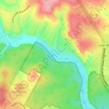
Hill of Life Falls topographic map
Interactive map
Click on the map to display elevation.
About this map
Name: Hill of Life Falls topographic map, elevation, terrain.
Average elevation: 764 ft
Minimum elevation: 571 ft
Maximum elevation: 965 ft
Other topographic maps
Click on a map to view its topography, its elevation and its terrain.
Walnut Creek Metropolitan Park
United States > Texas > Travis County > Austin
Walnut Creek Metropolitan Park, Austin, Travis County, Texas, United States
Average elevation: 702 ft
East Boggy Creek Greenbelt
United States > Texas > Travis County > Austin
East Boggy Creek Greenbelt, Austin, Travis County, Texas, United States
Average elevation: 472 ft
Lady Bird Lake
United States > Texas > Travis County > Austin
Lady Bird Lake, Austin, Travis County, Texas, United States
Average elevation: 561 ft
Gus Fruh Park
United States > Texas > Travis County > Austin
Gus Fruh Park, Austin, Travis County, Texas, 78704, United States
Average elevation: 636 ft
Zilker Park
United States > Texas > Travis County > Austin
Zilker Park, Austin, Travis County, Texas, 78746, United States
Average elevation: 512 ft
Shoal Creek
United States > Texas > Travis County > Austin
Shoal Creek, Austin, Travis County, Texas, 78731:78759, United States
Average elevation: 781 ft
Mayfield Park
United States > Texas > Travis County > Austin
Mayfield Park, Austin, Travis County, Texas, United States
Average elevation: 591 ft
Boggy Creek
United States > Texas > Travis County > Austin
Boggy Creek, M Station Apartments, Austin, Travis County, Texas, 78722, United States
Average elevation: 568 ft
Colorado River
United States > Texas > Travis County > Austin
Colorado River, Austin, Travis County, Texas, 78732, United States
Average elevation: 689 ft
Mount Bonnell
United States > Texas > Travis County > Austin
Mount Bonnell, Austin, Travis County, Texas, 78731, United States
Average elevation: 620 ft
Mabel Davis District Park
United States > Texas > Travis County > Austin
Mabel Davis District Park, Austin, Travis County, Texas, United States
Average elevation: 627 ft
Dick Nichols District Park
United States > Texas > Travis County > Austin
Dick Nichols District Park, Austin, Travis County, Texas, 78749, United States
Average elevation: 807 ft
Walter E Long Lake
United States > Texas > Travis County > Austin
Walter E Long Lake, Austin, Travis County, Texas, United States
Average elevation: 577 ft
Barton Creek Greenbelt -- Gus Fruh Access
United States > Texas > Travis County > Austin
Barton Creek Greenbelt -- Gus Fruh Access, Horseshoe Bend, Austin, Travis County, Texas, 78704, United States
Average elevation: 630 ft
Mary Moore Searight zMetropolitan Park
United States > Texas > Travis County > Austin
Mary Moore Searight zMetropolitan Park, Austin, Travis County, Texas, United States
Average elevation: 659 ft
Onion Creek
United States > Texas > Travis County > Austin
Onion Creek, Austin, Travis County, Texas, 78744, United States
Average elevation: 535 ft
Walnut Creek
United States > Texas > Travis County > Austin
Walnut Creek, Austin, Travis County, Texas, 78753, United States
Average elevation: 640 ft
Longview Neighborhood Park
United States > Texas > Travis County > Austin
Longview Neighborhood Park, Austin, Travis County, Texas, 78745, United States
Average elevation: 768 ft
Cat Mountain
United States > Texas > Travis County > Austin
Cat Mountain, Austin, Travis County, Texas, 78731, United States
Average elevation: 679 ft
Tarrytown Neighborhood Park
United States > Texas > Travis County > Austin
Tarrytown Neighborhood Park, Old West Austin, Austin, Travis County, Texas, United States
Average elevation: 587 ft
Mount Barker
United States > Texas > Travis County > Austin
Mount Barker, Austin, Travis County, Texas, 78731, United States
Average elevation: 633 ft