Geolocate

Cat Mountain topographic map

Click on the map to display elevation.

About this map

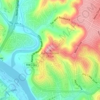
Name: Cat Mountain topographic map, elevation, terrain.

Location: Cat Mountain, Austin, Travis County, Texas, 78731, United States (30.35238 -97.77978 30.35248 -97.77968)

Average elevation: 679 ft

Minimum elevation: 495 ft

Maximum elevation: 925 ft

Travis County trails, hiking, mountain biking, running and outdoor activities

Other topographic maps

Click on a map to view its topography, its elevation and its terrain.

Lady Bird Lake

United States > Texas > Travis County > Austin

Average elevation: 561 ft

Lake Austin

United States > Texas > Travis County > Austin

Average elevation: 794 ft

Shoal Creek

United States > Texas > Travis County > Austin

Average elevation: 781 ft

Colorado River

United States > Texas > Travis County > Austin

Average elevation: 689 ft

Walnut Creek

United States > Texas > Travis County > Austin

Average elevation: 640 ft

Walter E Long Lake

United States > Texas > Travis County > Austin

Average elevation: 577 ft

Boggy Creek

United States > Texas > Travis County > Austin

Average elevation: 568 ft

Zilker Park

United States > Texas > Travis County > Austin

Average elevation: 512 ft

Gear up for your next adventure:

🧭Compass with Lanyard - Easy‑carry compass for navigation
🏕️Tent Footprint - Protect your tent base from wear
🔦LED Headlamp - Bright and durable LED headlamp for night navigation
🌡️Handheld Weather Meters - Measure wind, temp, and pressure for safe mountain travel
🌲Outdoor Survival Books - Best books on survival skills

As an Amazon Associate, this site earns from qualifying purchases at no extra cost to you.