
Make a donation
Gear up for your next adventure:
As an Amazon Associate, this site earns from qualifying purchases at no extra cost to you.
Swisshome topographic map
Click on the map to display elevation.
Make a donation
Gear up for your next adventure:
As an Amazon Associate, this site earns from qualifying purchases at no extra cost to you.
About this map
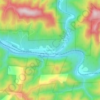
Name: Swisshome topographic map, elevation, terrain.
Location: Swisshome, Lane County, Oregon, 97480, United States (44.03790 -123.81927 44.07790 -123.77927)
Average elevation: 728 ft
Minimum elevation: 69 ft
Maximum elevation: 1,752 ft
Lane County trails, hiking, mountain biking, running and outdoor activities
Make a donation
Gear up for your next adventure:
As an Amazon Associate, this site earns from qualifying purchases at no extra cost to you.
Other topographic maps
Click on a map to view its topography, its elevation and its terrain.
Waldo Lake Wilderness
United States > Oregon > Lane County
Ninety-eight percent of the Waldo Lake Wilderness is covered by forest on moderate to steep terrain, which ranges in elevation from 2,800 to 7,144 feet (853 to 2,177 m).
Average elevation: 5,013 ft
McKenzie River
United States > Oregon > Lane County
The McKenzie River drains a region of about 1,300 square miles (3,400 km2) and is one of the primary tributaries of the Willamette River. Elevations in the watershed range from 10,358 feet (3,157 m) at the summit of the South Sister to 375 feet (114 m) at the McKenzie's mouth on the Willamette River north of…
Average elevation: 2,290 ft
Make a donation
Gear up for your next adventure:
As an Amazon Associate, this site earns from qualifying purchases at no extra cost to you.
McKenzie River
United States > Oregon > Lane County > Rainbow
The McKenzie River drains a region of about 1,300 square miles (3,400 km2) and is one of the primary tributaries of the Willamette River. Elevations in the watershed range from 10,358 feet (3,157 m) at the summit of the South Sister to 375 feet (114 m) at the McKenzie's mouth on the Willamette River north of…
Average elevation: 1,414 ft
Make a donation
Gear up for your next adventure:
As an Amazon Associate, this site earns from qualifying purchases at no extra cost to you.
Washington/Jefferson City Park
United States > Oregon > Lane County > Eugene
Average elevation: 427 ft