Geolocate

Dorena Lake topographic map

Click on the map to display elevation.

About this map

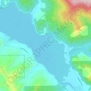
Name: Dorena Lake topographic map, elevation, terrain.

Location: Dorena Lake, Lane County, Oregon, United States (43.75021 -122.95545 43.79011 -122.89726)

Average elevation: 1,086 ft

Minimum elevation: 771 ft

Maximum elevation: 2,346 ft

Lane County trails, hiking, mountain biking, running and outdoor activities

Other topographic maps

Click on a map to view its topography, its elevation and its terrain.

Skinner Butte

United States > Oregon > Lane County > Eugene

Average elevation: 427 ft

Leaburg

United States > Oregon > Lane County

Average elevation: 1,165 ft

Pleasant Hill

United States > Oregon > Lane County

Average elevation: 600 ft

Alpha

United States > Oregon > Lane County

Average elevation: 817 ft

Mabel

United States > Oregon > Lane County

Average elevation: 843 ft

Mill Camp

United States > Oregon > Lane County

Average elevation: 866 ft

Short Mountain

United States > Oregon > Lane County

Average elevation: 617 ft

Walton

United States > Oregon > Lane County

Average elevation: 758 ft

Marcola

United States > Oregon > Lane County

Average elevation: 732 ft

Swisshome

United States > Oregon > Lane County

Average elevation: 728 ft

Cheshire

United States > Oregon > Lane County

Average elevation: 358 ft

McKenzie River

United States > Oregon > Lane County > Rainbow

The McKenzie River drains a region of about 1,300 square miles (3,400 km2) and is one of the primary tributaries of the Willamette River. Elevations in the watershed range from 10,358 feet (3,157 m) at the summit of the South Sister to 375 feet (114 m) at the McKenzie's mouth on the Willamette River north of…

Average elevation: 1,414 ft

West Bank City Park

United States > Oregon > Lane County > Eugene

Average elevation: 410 ft

Elmira

United States > Oregon > Lane County > Elmira

Average elevation: 394 ft

Saddle Camp Butte

United States > Oregon > Lane County

Average elevation: 3,192 ft

Culp Creek

United States > Oregon > Lane County

Average elevation: 1,555 ft

Noti

United States > Oregon > Lane County > Noti

Average elevation: 659 ft

Cupit Mary Mountain

United States > Oregon > Lane County

Average elevation: 5,584 ft

Rainbow

United States > Oregon > Lane County

Average elevation: 1,594 ft

Gear up for your next adventure:

😴Insulated Sleeping Pads - Compact and warm pads for high-elevation camping
🧴Hand Sanitizer - Keep hands clean while hiking
🥾Men's Hiking Boots - Durable, waterproof footwear for rugged terrain and steep inclines
GPS Sports Watch - GPS watch for running, hiking and training
🥾Women's Hiking Boots - Top-rated trail boots with ankle support and superior grip

As an Amazon Associate, this site earns from qualifying purchases at no extra cost to you.