Geolocate

Cheshire topographic map

Click on the map to display elevation.

About this map

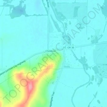
Name: Cheshire topographic map, elevation, terrain.

Location: Cheshire, Lane County, Oregon, United States (44.17612 -123.29069 44.20174 -123.27434)

Average elevation: 358 ft

Minimum elevation: 299 ft

Maximum elevation: 650 ft

Lane County trails, hiking, mountain biking, running and outdoor activities

Other topographic maps

Click on a map to view its topography, its elevation and its terrain.

Leaburg

United States > Oregon > Lane County

Average elevation: 1,165 ft

Pleasant Hill

United States > Oregon > Lane County

Average elevation: 600 ft

Alpha

United States > Oregon > Lane County

Average elevation: 817 ft

Mabel

United States > Oregon > Lane County

Average elevation: 843 ft

Mill Camp

United States > Oregon > Lane County

Average elevation: 866 ft

Waldo Lake Wilderness

United States > Oregon > Lane County

Ninety-eight percent of the Waldo Lake Wilderness is covered by forest on moderate to steep terrain, which ranges in elevation from 2,800 to 7,144 feet (853 to 2,177 m).

Average elevation: 5,013 ft

Short Mountain

United States > Oregon > Lane County

Average elevation: 617 ft

Walton

United States > Oregon > Lane County

Average elevation: 758 ft

Noti

United States > Oregon > Lane County > Noti

Average elevation: 659 ft

Marcola

United States > Oregon > Lane County

Average elevation: 732 ft

McKenzie River

United States > Oregon > Lane County

The McKenzie River drains a region of about 1,300 square miles (3,400 km2) and is one of the primary tributaries of the Willamette River. Elevations in the watershed range from 10,358 feet (3,157 m) at the summit of the South Sister to 375 feet (114 m) at the McKenzie's mouth on the Willamette River north of…

Average elevation: 2,290 ft

Swisshome

United States > Oregon > Lane County

Average elevation: 728 ft

Dorena Lake

United States > Oregon > Lane County

Average elevation: 1,086 ft

Skinner Butte

United States > Oregon > Lane County > Eugene

Average elevation: 427 ft

Saddle Camp Butte

United States > Oregon > Lane County

Average elevation: 3,192 ft

Culp Creek

United States > Oregon > Lane County

Average elevation: 1,555 ft

Cupit Mary Mountain

United States > Oregon > Lane County

Average elevation: 5,584 ft

Rainbow

United States > Oregon > Lane County

Average elevation: 1,594 ft

Gear up for your next adventure:

📱Heavy-Duty Phone Cases - Drop-proof and waterproof protection for outdoor navigation
🧤Hiking Gloves - Protective gloves for rugged trails
❄️Traction Cleats - Prevent slips on icy trails during winter hikes
🚪Portable Camp Chair - Foldable chair for comfort at camp
🪶Compact Camp Shovel - Folding shovel for campsite tasks

As an Amazon Associate, this site earns from qualifying purchases at no extra cost to you.