Geolocate

Dieteren topographic map

Click on the map to display elevation.

About this map

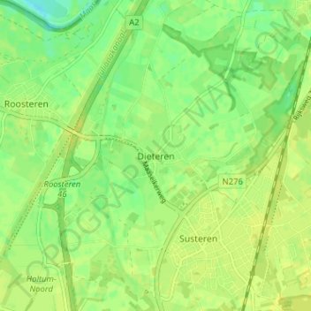
Name: Dieteren topographic map, elevation, terrain.

Location: Dieteren, Susteren, Echt-Susteren, Limburg, Netherlands, 6114 JT, Netherlands (51.05598 5.82319 51.09598 5.86319)

Average elevation: 98 ft

Minimum elevation: 66 ft

Maximum elevation: 115 ft

Other topographic maps

Click on a map to view its topography, its elevation and its terrain.

Eygelshoven

Netherlands > Limburg

Average elevation: 387 ft

Heerlen

Netherlands > Limburg

Heerlen's high elevation makes it one of the highest cities above sea level in the Netherlands.

Average elevation: 430 ft

Holtum

Netherlands > Limburg

Average elevation: 108 ft

Maastricht

Netherlands > Limburg

Average elevation: 236 ft

Maastricht

Netherlands > Limburg

Average elevation: 240 ft

Landgraaf

Netherlands > Limburg

Dutch topographic map of the municipality of Landgraaf, June 2015

Average elevation: 413 ft

Kerkrade

Netherlands > Limburg

Average elevation: 459 ft

Susteren

Netherlands > Limburg

Average elevation: 105 ft

Broekhuizen

Netherlands > Limburg

Average elevation: 62 ft

Brunssum

Netherlands > Limburg

Average elevation: 295 ft

Swalmen

Netherlands > Limburg

Average elevation: 85 ft

Sittard

Netherlands > Limburg

Average elevation: 171 ft

Arcen

Netherlands > Limburg

Average elevation: 66 ft

Maasbree

Netherlands > Limburg

Average elevation: 95 ft

Mook

Netherlands > Limburg

Average elevation: 95 ft

Baarlo

Netherlands > Limburg

Average elevation: 79 ft

Valkenburg aan de Geul

Netherlands > Limburg

Average elevation: 390 ft

Posterholt

Netherlands > Limburg

Average elevation: 108 ft

Stein

Netherlands > Limburg

Average elevation: 174 ft

Weert

Netherlands > Limburg

Average elevation: 108 ft

Gennep

Netherlands > Limburg

Average elevation: 52 ft

Kessel

Netherlands > Limburg

Average elevation: 89 ft

Maasbracht

Netherlands > Limburg

Average elevation: 82 ft

Urmond

Netherlands > Limburg

Average elevation: 141 ft

Maastricht

Netherlands > Limburg

Average elevation: 240 ft

Vaals

Netherlands > Limburg

Average elevation: 650 ft

Meuse

Netherlands > Limburg > Baarlo

Average elevation: 72 ft

Sevenum

Netherlands > Limburg

Average elevation: 95 ft

Bunde

Netherlands > Limburg

Average elevation: 197 ft

Cadier en Keer

Netherlands > Limburg

Average elevation: 377 ft

Gulpen

Netherlands > Limburg

Average elevation: 463 ft

Weert

Netherlands > Limburg

Average elevation: 108 ft

Kerkrade

Netherlands > Limburg

Average elevation: 456 ft

Valkenburg

Netherlands > Limburg

Average elevation: 404 ft

Wilhelminapark

Netherlands > Limburg > Venlo

Average elevation: 75 ft

Venlo

Netherlands > Limburg

Average elevation: 105 ft

Maastricht

Netherlands > Limburg

Average elevation: 240 ft

Schinveld

Netherlands > Limburg

Average elevation: 236 ft

Venray

Netherlands > Limburg

Average elevation: 85 ft

Maastricht

Netherlands > Limburg

Average elevation: 240 ft

Meuse

Netherlands > Limburg > Baarlo

Average elevation: 72 ft

Roosteren

Netherlands > Limburg

Average elevation: 98 ft

Panningen

Netherlands > Limburg

Average elevation: 112 ft

Well

Netherlands > Limburg

Average elevation: 59 ft

Vaals

Netherlands > Limburg

Average elevation: 741 ft

Amstenrade

Netherlands > Limburg

Average elevation: 322 ft

Landgraaf

Netherlands > Limburg

Dutch topographic map of the municipality of Landgraaf, June 2015

Average elevation: 413 ft

Brunssum

Netherlands > Limburg

Average elevation: 295 ft

Geulle

Netherlands > Limburg

Average elevation: 246 ft

Helden

Netherlands > Limburg

Average elevation: 105 ft

Epen

Netherlands > Limburg

Average elevation: 554 ft

Vijlen

Netherlands > Limburg

Average elevation: 623 ft

Vaals

Netherlands > Limburg

Average elevation: 650 ft

Vaals

Netherlands > Limburg

Average elevation: 650 ft

Windraak

Netherlands > Limburg

Average elevation: 295 ft

Venray

Netherlands > Limburg

Average elevation: 85 ft

Kasteel Rivieren

Netherlands > Limburg > Klimmen > Weustenrade

Average elevation: 285 ft

Maastricht

Netherlands > Limburg

Average elevation: 240 ft

Maastricht

Netherlands > Limburg

Average elevation: 240 ft

Voerendaal

Netherlands > Limburg

Dutch topographic map of the municipality of Voerendaal, June 2015

Average elevation: 400 ft

Oirsbeek

Netherlands > Limburg

Average elevation: 315 ft

Meijel

Netherlands > Limburg

Average elevation: 105 ft

Sittard

Netherlands > Limburg

Average elevation: 171 ft

Koningsbosch

Netherlands > Limburg

Average elevation: 180 ft

Hoensbroek

Netherlands > Limburg

Average elevation: 295 ft

Nuth

Netherlands > Limburg

Average elevation: 312 ft

Heerlen

Netherlands > Limburg

Heerlen's high elevation makes it one of the highest cities above sea level in the Netherlands.

Average elevation: 430 ft

Ysselsteyn

Netherlands > Limburg

Average elevation: 102 ft

Maastricht-Airport

Netherlands > Limburg

Average elevation: 367 ft

Siebengewald

Netherlands > Limburg

Average elevation: 56 ft

Brunssum

Netherlands > Limburg

Average elevation: 295 ft

Eijsden-Margraten

Netherlands > Limburg

Average elevation: 377 ft

Roermond

Netherlands > Limburg

Average elevation: 82 ft

Reuver

Netherlands > Limburg

Average elevation: 89 ft

Venlo

Netherlands > Limburg > Venlo

Average elevation: 89 ft

Geleen

Netherlands > Limburg

Average elevation: 207 ft

Valkenburg

Netherlands > Limburg

Average elevation: 404 ft

Born

Netherlands > Limburg

Average elevation: 112 ft

Elsloo

Netherlands > Limburg > Elsloo

Average elevation: 220 ft

Geul

Netherlands > Limburg

Average elevation: 525 ft

Herkenbosch

Netherlands > Limburg > Herkenbosch

Average elevation: 125 ft

Roermond

Netherlands > Limburg

Average elevation: 82 ft

Castenray

Netherlands > Limburg

Average elevation: 82 ft

Limbricht

Netherlands > Limburg > Limbricht

Average elevation: 138 ft

Swalmen

Netherlands > Limburg > Swalmen

Average elevation: 85 ft

Eijsden

Netherlands > Limburg

Average elevation: 240 ft

Zuid-Limburg

Netherlands > Limburg

Average elevation: 331 ft

Simpelveld

Netherlands > Limburg

Average elevation: 568 ft

Kerkrade

Netherlands > Limburg

Average elevation: 459 ft

Meuse

Netherlands > Limburg > Maastricht > Borgharen

Average elevation: 157 ft

Gear up for your next adventure:

🧯Emergency Survival Kit - All‑in‑one survival essentials for the backcountry
🎒Waterproof Dry Bags - Keep your electronics and maps dry inside your pack
🥇GPS Hiking Watch - Multi‑sport GPS watch with navigation and trail tracking
🌐World Map Poster - Decorative world maps with topographic info
🛡️Bear Spray Outdoor - Protection in bear country hikes

As an Amazon Associate, this site earns from qualifying purchases at no extra cost to you.