Geolocate

Landgraaf topographic map

Click on the map to display elevation.

Landgraaf

Dutch topographic map of the municipality of Landgraaf, June 2015

Wikipedia (CC-BY-SA 3.0)

About this map

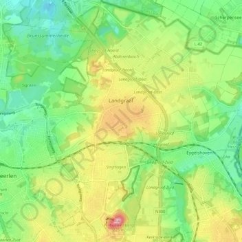
Name: Landgraaf topographic map, elevation, terrain.

Location: Landgraaf, Limburg, Netherlands (50.87022 5.99063 50.93470 6.09418)

Average elevation: 413 ft

Minimum elevation: 230 ft

Maximum elevation: 696 ft

Other topographic maps

Click on a map to view its topography, its elevation and its terrain.

Valkenburg

Netherlands > Limburg > Valkenburg

Average elevation: 397 ft

Cannerberg

Netherlands > Limburg > Maastricht

Average elevation: 276 ft

Maasveld I

Netherlands > Limburg > Tegelen

Average elevation: 75 ft

Dieteren

Netherlands > Limburg

Average elevation: 98 ft

Houthem

Netherlands > Limburg > Valkenburg

Average elevation: 344 ft

Meuse

Netherlands > Limburg > Baarlo

Average elevation: 72 ft

Rodeput

Netherlands > Limburg > Simpelveld

Average elevation: 568 ft

Plaat

Netherlands > Limburg > Epen

Average elevation: 558 ft

Meuse

Netherlands > Limburg > Baarlo

Average elevation: 72 ft

Kasteel Rivieren

Netherlands > Limburg > Klimmen > Weustenrade

Average elevation: 285 ft

Helle

Netherlands > Limburg > Mechelen

Average elevation: 518 ft

Nieuw Bergen

Netherlands > Limburg

Average elevation: 52 ft

Daniken

Netherlands > Limburg > Geleen

Average elevation: 236 ft

Palemig

Netherlands > Limburg > Heerlen

Average elevation: 377 ft

Heide

Netherlands > Limburg > Susteren

Average elevation: 105 ft

Kapolder

Netherlands > Limburg > Wijlre

Average elevation: 417 ft

Vrij

Netherlands > Limburg > Siebengewald

Average elevation: 52 ft

Maastricht

Netherlands > Limburg > Maastricht

Average elevation: 331 ft

Panheel

Netherlands > Limburg > Heel > Panheel

Average elevation: 85 ft

Voulwames

Netherlands > Limburg > Bunde > Voulwames

Average elevation: 167 ft

Sint-Pietersberg

Netherlands > Limburg > Maastricht

Average elevation: 233 ft

Holset

Netherlands > Limburg

Average elevation: 682 ft

Ubachsberg

Netherlands > Limburg > Ubachsberg

Average elevation: 538 ft

Eys

Netherlands > Limburg > Eys > Eys

Average elevation: 486 ft

Hout-Blerick

Netherlands > Limburg > Venlo

Average elevation: 72 ft

Meuse

Netherlands > Limburg > Maastricht > Borgharen

Average elevation: 157 ft

Gear up for your next adventure:

Camping Coffee Makers - Enjoy premium coffee at the summit or campsite
🪶Trail Camera - Capture wildlife on your hikes
🎒Gear Packing Cubes - Organize your backpack efficiently
🏔️Mountain Trail Maps - High‑detail maps for popular peaks
🧭Outdoor Navigation Book - Learn advanced navigation skills

As an Amazon Associate, this site earns from qualifying purchases at no extra cost to you.