Geolocate

Erwin topographic map

Click on the map to display elevation.

About this map

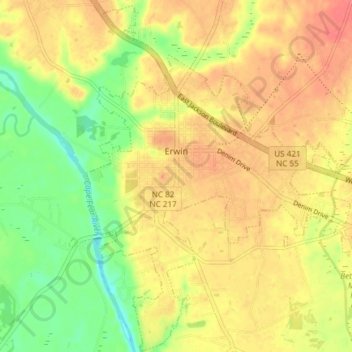
Name: Erwin topographic map, elevation, terrain.

Location: Erwin, Harnett County, North Carolina, 28339, United States (35.29218 -78.69899 35.35198 -78.64153)

Average elevation: 164 ft

Minimum elevation: 59 ft

Maximum elevation: 240 ft

Harnett County trails, hiking, mountain biking, running and outdoor activities

Other topographic maps

Click on a map to view its topography, its elevation and its terrain.

Rawls

United States > North Carolina > Harnett County

Average elevation: 335 ft

Bunnlevel

United States > North Carolina > Harnett County

Average elevation: 144 ft

Westhaven

United States > North Carolina > Harnett County > Dunn

Average elevation: 210 ft

Barbecue

United States > North Carolina > Harnett County

Average elevation: 285 ft

Bunnlevel

United States > North Carolina > Harnett County

Average elevation: 144 ft

Gear up for your next adventure:

🧣Merino Neck Gaiters - Multi-functional headwear for wind and sun protection
🛶Inflatable Kayak - Portable kayak for rivers, lakes, and expeditions
🌡️Portable Weather Meter - Track weather conditions on the trail
📚USA Hiking Guide Books - Top trail guides and map books
🌎3D Topographic Globes - Raised relief globes for a tactile understanding of geography

As an Amazon Associate, this site earns from qualifying purchases at no extra cost to you.