
Make a donation
Gear up for your next adventure:
As an Amazon Associate, this site earns from qualifying purchases at no extra cost to you.
Village of Cold Spring topographic map
Click on the map to display elevation.
Make a donation
Gear up for your next adventure:
As an Amazon Associate, this site earns from qualifying purchases at no extra cost to you.
About this map
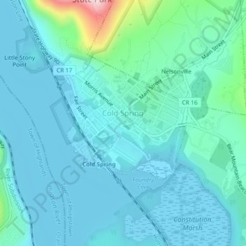
Name: Village of Cold Spring topographic map, elevation, terrain.
Average elevation: 141 ft
Minimum elevation: -3 ft
Maximum elevation: 1,020 ft
Putnam County trails, hiking, mountain biking, running and outdoor activities
Make a donation
Gear up for your next adventure:
As an Amazon Associate, this site earns from qualifying purchases at no extra cost to you.
Other topographic maps
Click on a map to view its topography, its elevation and its terrain.
Oscawana Corners
United States > New York > Putnam County > Town of Putnam Valley
Average elevation: 518 ft
Make a donation
Gear up for your next adventure:
As an Amazon Associate, this site earns from qualifying purchases at no extra cost to you.
Lake Peekskill
United States > New York > Putnam County > Town of Putnam Valley
Average elevation: 338 ft
Make a donation
Gear up for your next adventure:
As an Amazon Associate, this site earns from qualifying purchases at no extra cost to you.
Barnum Corners
United States > New York > Putnam County > Town of Patterson > Putnam Lake
Average elevation: 571 ft
Lake Tonetta
United States > New York > Putnam County > Brewster > Brewster Hill
Average elevation: 509 ft
Make a donation
Gear up for your next adventure:
As an Amazon Associate, this site earns from qualifying purchases at no extra cost to you.
Crofts Corners
United States > New York > Putnam County > Town of Putnam Valley
Average elevation: 463 ft
Make a donation
Gear up for your next adventure:
As an Amazon Associate, this site earns from qualifying purchases at no extra cost to you.
Kent Cliffs Unit
United States > New York > Putnam County > Town of Putnam Valley > Richardsville
Average elevation: 886 ft
Make a donation
Gear up for your next adventure:
As an Amazon Associate, this site earns from qualifying purchases at no extra cost to you.
Tompkins Corners
United States > New York > Putnam County > Town of Putnam Valley
Average elevation: 682 ft
Stillwater Pond
United States > New York > Putnam County > Town of Putnam Valley
Average elevation: 945 ft
Make a donation
Gear up for your next adventure:
As an Amazon Associate, this site earns from qualifying purchases at no extra cost to you.