
Perdido River topographic map
Click on the map to display elevation.
About this map
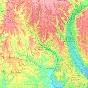
Name: Perdido River topographic map, elevation, terrain.
Location: Perdido River, Baldwin County, Alabama, 35507, United States (30.44972 -87.63490 31.03127 -87.38909)
Average elevation: 141 ft
Minimum elevation: -13 ft
Maximum elevation: 312 ft
Baldwin County trails, hiking, mountain biking, running and outdoor activities
Other topographic maps
Click on a map to view its topography, its elevation and its terrain.
Fairhope
United States > Alabama > Baldwin County > Fairhope
According to the U.S. Census Bureau, the city has a total area of 12.0 square miles (31.1 km2), of which 0.019 square mile (0.05 km2), or 0.16%, is water. Its elevation ranges from sea level at the bay to 122 feet (37 m) in the city center.
Average elevation: 115 ft
Gulf Shores
United States > Alabama > Baldwin County
Jack Edwards National Airport is located in Gulf Shores and offers services from Gulf Air Center, Salt Air Aviation Center and Platium Air Center. The airport is located in town, two miles from the beach. Their FBO Gulf Air Center will provide a rental vehicle while they take care of fueling and storing…
Average elevation: 13 ft