
Bay Minette topographic map
Click on the map to display elevation.
About this map
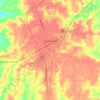
Name: Bay Minette topographic map, elevation, terrain.
Location: Bay Minette, Baldwin County, Alabama, 36507, United States (30.83679 -87.79971 30.91506 -87.75079)
Average elevation: 236 ft
Minimum elevation: 85 ft
Maximum elevation: 295 ft
Baldwin County trails, hiking, mountain biking, running and outdoor activities
Other topographic maps
Click on a map to view its topography, its elevation and its terrain.
Gulf Shores
United States > Alabama > Baldwin County
Jack Edwards National Airport is located in Gulf Shores and offers services from Gulf Air Center, Salt Air Aviation Center and Platium Air Center. The airport is located in town, two miles from the beach. Their FBO Gulf Air Center will provide a rental vehicle while they take care of fueling and storing…
Average elevation: 13 ft