Geolocate

Greenfield topographic map

Click on the map to display elevation.

About this map

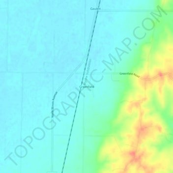
Name: Greenfield topographic map, elevation, terrain.

Location: Greenfield, Poinsett County, Arkansas, United States (35.61230 -90.73261 35.65230 -90.69261)

Average elevation: 285 ft

Minimum elevation: 240 ft

Maximum elevation: 433 ft

Poinsett County trails, hiking, mountain biking, running and outdoor activities

Other topographic maps

Click on a map to view its topography, its elevation and its terrain.

Lepanto

United States > Arkansas > Poinsett County

Average elevation: 220 ft

Waldenburg

United States > Arkansas > Poinsett County

Average elevation: 240 ft

Fisher

United States > Arkansas > Poinsett County

Average elevation: 230 ft

Tyronza

United States > Arkansas > Poinsett County

Average elevation: 220 ft

Gear up for your next adventure:

🛠️Outdoor Gear Repair Kit - Essential tools to fix gear on the trail
🔦Compact Flashlight - Reliable flashlight for emergencies
🗺️Topographic Maps - Detailed topo maps for hiking, exploring and outdoor navigation
📻Weather Alert Radios - Stay informed of storm risks while off-the-grid
🧯Emergency Survival Kit - All‑in‑one survival essentials for the backcountry

As an Amazon Associate, this site earns from qualifying purchases at no extra cost to you.