
Make a donation
Gear up for your next adventure:
As an Amazon Associate, this site earns from qualifying purchases at no extra cost to you.
Thornloe topographic map
Click on the map to display elevation.
Make a donation
Gear up for your next adventure:
As an Amazon Associate, this site earns from qualifying purchases at no extra cost to you.
About this map
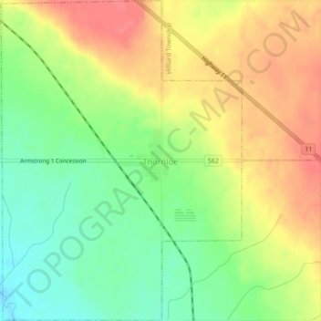
Name: Thornloe topographic map, elevation, terrain.
Average elevation: 741 ft
Minimum elevation: 636 ft
Maximum elevation: 843 ft
Make a donation
Gear up for your next adventure:
As an Amazon Associate, this site earns from qualifying purchases at no extra cost to you.
Other topographic maps
Click on a map to view its topography, its elevation and its terrain.
Henwood Lake
Canada > Ontario > Timiskaming District > Unorganized West Timiskaming
Average elevation: 945 ft
Make a donation
Gear up for your next adventure:
As an Amazon Associate, this site earns from qualifying purchases at no extra cost to you.
Make a donation
Gear up for your next adventure:
As an Amazon Associate, this site earns from qualifying purchases at no extra cost to you.
Boston Creek
Canada > Ontario > Timiskaming District > Unorganized West Timiskaming
Average elevation: 984 ft
Heart Lake
Canada > Ontario > Timiskaming District > Unorganized West Timiskaming > King Kirkland
Average elevation: 1,102 ft
Make a donation
Gear up for your next adventure:
As an Amazon Associate, this site earns from qualifying purchases at no extra cost to you.
Kenabeek
Canada > Ontario > Timiskaming District > Unorganized West Timiskaming
Average elevation: 932 ft
Hobart Lake
Canada > Ontario > Timiskaming District > Unorganized West Timiskaming
Average elevation: 1,001 ft
Flanagan Lake
Canada > Ontario > Timiskaming District > Unorganized West Timiskaming
Average elevation: 1,322 ft
Make a donation
Gear up for your next adventure:
As an Amazon Associate, this site earns from qualifying purchases at no extra cost to you.
Baptiste Creek;Baptiste Lake
Canada > Ontario > Timiskaming District > Unorganized West Timiskaming
Average elevation: 1,096 ft
Make a donation
Gear up for your next adventure:
As an Amazon Associate, this site earns from qualifying purchases at no extra cost to you.