
Matamoras topographic map
Click on the map to display elevation.
About this map
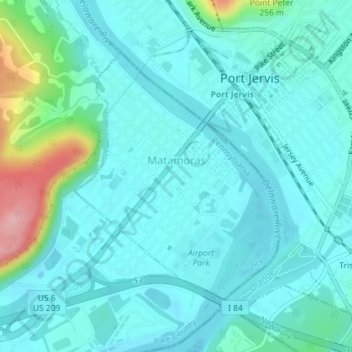
Name: Matamoras topographic map, elevation, terrain.
Location: Matamoras, Pike County, Pennsylvania, United States (41.35780 -74.71056 41.37709 -74.68967)
Average elevation: 482 ft
Minimum elevation: 387 ft
Maximum elevation: 948 ft
Pike County trails, hiking, mountain biking, running and outdoor activities
Other topographic maps
Click on a map to view its topography, its elevation and its terrain.
Dingmans Ferry
United States > Pennsylvania > Pike County > Delaware Township
Average elevation: 630 ft
Lake in the Clouds
United States > Pennsylvania > Pike County > Greene Township
Average elevation: 1,841 ft
Lords Valley
United States > Pennsylvania > Pike County > Blooming Grove Township
Average elevation: 1,352 ft
Birchwood Lakes
United States > Pennsylvania > Pike County > Delaware Township
Average elevation: 1,119 ft
Parkers Glen
United States > Pennsylvania > Pike County > Shohola Township
Average elevation: 1,007 ft
Promised Land
United States > Pennsylvania > Pike County > Greene Township
Average elevation: 1,772 ft
Sagamore Estates
United States > Pennsylvania > Pike County > Shohola Township
Average elevation: 1,352 ft
Birchwood Lakes
United States > Pennsylvania > Pike County > Delaware Township
Average elevation: 1,119 ft
Gold Key Lake
United States > Pennsylvania > Pike County > Dingman Township
Average elevation: 1,316 ft
Pocono Mountain Woodland Lakes
United States > Pennsylvania > Pike County > Dingman Township
Average elevation: 1,211 ft
Tanglewood Estate
United States > Pennsylvania > Pike County > Palmyra Township
Average elevation: 1,470 ft
Promised Land
United States > Pennsylvania > Pike County > Greene Township
Average elevation: 1,772 ft
Masthope Rapids
United States > Pennsylvania > Pike County > Lackawaxen Township
Average elevation: 1,027 ft
Dingmans Ferry
United States > Pennsylvania > Pike County > Delaware Township
Average elevation: 630 ft
Lords Valley
United States > Pennsylvania > Pike County > Blooming Grove Township
Average elevation: 1,352 ft
Sagamore Estates
United States > Pennsylvania > Pike County > Shohola Township
Average elevation: 1,352 ft
Saw Creek
United States > Pennsylvania > Pike County > Lehman Township > Saw Creek
Average elevation: 906 ft