
Make a donation
Gear up for your next adventure:
As an Amazon Associate, this site earns from qualifying purchases at no extra cost to you.
Colina topographic map
Click on the map to display elevation.
Make a donation
Gear up for your next adventure:
As an Amazon Associate, this site earns from qualifying purchases at no extra cost to you.
About this map
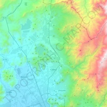
Name: Colina topographic map, elevation, terrain.
Average elevation: 3,707 ft
Minimum elevation: 1,555 ft
Maximum elevation: 11,302 ft
Make a donation
Gear up for your next adventure:
As an Amazon Associate, this site earns from qualifying purchases at no extra cost to you.
Other topographic maps
Click on a map to view its topography, its elevation and its terrain.
Santa Ester Oriente
Chile > Región Metropolitana de Santiago > Provincia de Chacabuco > Colina
Average elevation: 1,768 ft
El Colorado
Chile > Región Metropolitana de Santiago > Provincia de Chacabuco > Colina
Average elevation: 2,110 ft
Rungue
Chile > Región Metropolitana de Santiago > Provincia de Chacabuco > Tiltil
Average elevation: 2,572 ft
Quilapilún Alto
Chile > Región Metropolitana de Santiago > Provincia de Chacabuco > Colina
Average elevation: 2,457 ft
Make a donation
Gear up for your next adventure:
As an Amazon Associate, this site earns from qualifying purchases at no extra cost to you.
Los Cántaros
Chile > Región Metropolitana de Santiago > Provincia de Chacabuco > Batuco
Average elevation: 1,617 ft
Rincón de Los Valles
Chile > Región Metropolitana de Santiago > Provincia de Chacabuco > Tiltil
Average elevation: 3,806 ft
Chamisero
Chile > Región Metropolitana de Santiago > Provincia de Chacabuco > Colina
Average elevation: 2,293 ft
Laguna Piedra Roja
Chile > Región Metropolitana de Santiago > Provincia de Chacabuco > Colina > Chicureo
Average elevation: 2,054 ft
Make a donation
Gear up for your next adventure:
As an Amazon Associate, this site earns from qualifying purchases at no extra cost to you.
Chicureo
Chile > Región Metropolitana de Santiago > Provincia de Chacabuco > Colina
Average elevation: 2,333 ft
Estación Colina
Chile > Región Metropolitana de Santiago > Provincia de Chacabuco
Average elevation: 1,624 ft
San José
Chile > Región Metropolitana de Santiago > Provincia de Chacabuco > Colina > Lo Arcaya
Average elevation: 1,762 ft
Make a donation
Gear up for your next adventure:
As an Amazon Associate, this site earns from qualifying purchases at no extra cost to you.
Canal El Carmen
Chile > Región Metropolitana de Santiago > Provincia de Chacabuco > Colina > Los Jardines de Colina
Average elevation: 1,749 ft
Chicauma
Chile > Región Metropolitana de Santiago > Provincia de Chacabuco
Average elevation: 1,611 ft
El Manzano
Chile > Región Metropolitana de Santiago > Provincia de Chacabuco > Colina
Average elevation: 2,671 ft
Peldehue
Chile > Región Metropolitana de Santiago > Provincia de Chacabuco > Colina
Average elevation: 2,438 ft
Make a donation
Gear up for your next adventure:
As an Amazon Associate, this site earns from qualifying purchases at no extra cost to you.
Santa Carolina Poniente
Chile > Región Metropolitana de Santiago > Provincia de Chacabuco > Batuco
Average elevation: 1,608 ft
Chacabuco
Chile > Región Metropolitana de Santiago > Provincia de Chacabuco > Colina
Average elevation: 2,395 ft
Lo Arcaya
Chile > Región Metropolitana de Santiago > Provincia de Chacabuco > Colina
Average elevation: 1,808 ft
Talavera
Chile > Región Metropolitana de Santiago > Provincia de Chacabuco > Colina > Chacabuco
Average elevation: 2,392 ft
Make a donation
Gear up for your next adventure:
As an Amazon Associate, this site earns from qualifying purchases at no extra cost to you.
Polpaico
Chile > Región Metropolitana de Santiago > Provincia de Chacabuco > Tiltil
Average elevation: 1,864 ft
Tunquelén
Chile > Región Metropolitana de Santiago > Provincia de Chacabuco > Lampa > Tunquelén
Average elevation: 1,660 ft
Polpaico
Chile > Región Metropolitana de Santiago > Provincia de Chacabuco > Tiltil
Average elevation: 1,864 ft
Rungue
Chile > Región Metropolitana de Santiago > Provincia de Chacabuco > Tiltil
Average elevation: 2,572 ft
Make a donation
Gear up for your next adventure:
As an Amazon Associate, this site earns from qualifying purchases at no extra cost to you.
Cerro Quilapilún
Chile > Región Metropolitana de Santiago > Provincia de Chacabuco > Colina
Average elevation: 2,516 ft
Chicureo
Chile > Región Metropolitana de Santiago > Provincia de Chacabuco > Colina
Average elevation: 2,333 ft
Condominio Los Olivos del Alba
Chile > Región Metropolitana de Santiago > Provincia de Chacabuco > Colina > Las Canteras
Average elevation: 1,942 ft
Make a donation
Gear up for your next adventure:
As an Amazon Associate, this site earns from qualifying purchases at no extra cost to you.
El Llano de Caleu
Chile > Región Metropolitana de Santiago > Provincia de Chacabuco > Tiltil
Average elevation: 3,963 ft
Las Pircas de Chicureo
Chile > Región Metropolitana de Santiago > Provincia de Chacabuco > Colina
Average elevation: 2,146 ft
Chicureo
Chile > Región Metropolitana de Santiago > Provincia de Chacabuco > Colina
Average elevation: 2,333 ft
Santa Elena
Chile > Región Metropolitana de Santiago > Provincia de Chacabuco > Colina
Average elevation: 1,900 ft
Make a donation
Gear up for your next adventure:
As an Amazon Associate, this site earns from qualifying purchases at no extra cost to you.
Chamisero
Chile > Región Metropolitana de Santiago > Provincia de Chacabuco > Colina
Average elevation: 2,293 ft