
Venetian Village topographic map
Interactive map
Click on the map to display elevation.
About this map
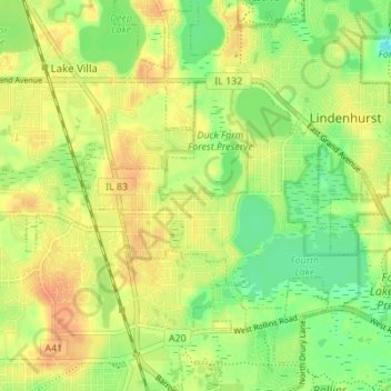
Name: Venetian Village topographic map, elevation, terrain.
Location: Venetian Village, Lake County, Illinois, United States (42.38565 -88.07292 42.41520 -88.00414)
Average elevation: 791 ft
Minimum elevation: 725 ft
Maximum elevation: 843 ft
Other topographic maps
Click on a map to view its topography, its elevation and its terrain.
Wadsworth
United States > Illinois > Lake County
Wadsworth, Lake County, Illinois, United States
Average elevation: 719 ft
Zion
United States > Illinois > Lake County
Zion, Lake County, Illinois, 60099, United States
Average elevation: 650 ft
Centenial Park
United States > Illinois > Lake County > Antioch
Centenial Park, Antioch, Lake County, Illinois, United States
Average elevation: 797 ft
Round Lake
United States > Illinois > Lake County
Round Lake, Lake County, Illinois, United States
Average elevation: 791 ft
Gages Lake
United States > Illinois > Lake County > Gages Lake
Gages Lake, Lake County, Illinois, 60031, United States
Average elevation: 774 ft
Beach Park
United States > Illinois > Lake County
Beach Park, Lake County, Illinois, United States
Average elevation: 686 ft
Great Lakes
United States > Illinois > Lake County > North Chicago
Great Lakes, North Chicago, Lake County, Illinois, 60088, United States
Average elevation: 659 ft
Forest Lake
United States > Illinois > Lake County
Forest Lake, Lake County, Illinois, United States
Average elevation: 820 ft
Buffalo Grove
United States > Illinois > Lake County
Buffalo Grove, Lake County, Illinois, 60089, United States
Average elevation: 686 ft
Deerpath
United States > Illinois > Lake County > Lake Forest
Deerpath, Lake Forest, Lake County, Illinois, 60045, United States
Average elevation: 686 ft
Fox Lake Hills
United States > Illinois > Lake County
Fox Lake Hills, Lake County, Illinois, United States
Average elevation: 761 ft
Lake Forest
United States > Illinois > Lake County
Lake Forest, Lake County, Illinois, 60045, United States
Average elevation: 653 ft
Bushs Corners
United States > Illinois > Lake County > Libertyville
Bushs Corners, Libertyville, Lake County, Illinois, 60048, United States
Average elevation: 732 ft
Mundelein
United States > Illinois > Lake County
Mundelein, Lake County, Illinois, 60060, United States
Average elevation: 758 ft
Lake Barrington
United States > Illinois > Lake County
Lake Barrington, Cuba, Lake County, Illinois, United States
Average elevation: 791 ft
Fox Lake
United States > Illinois > Lake County
Fox Lake, Lake County, Illinois, 60020, United States
Average elevation: 787 ft
Deep Lake
United States > Illinois > Lake County > Lake Villa
Deep Lake, Lake Villa, Lake County, Illinois, United States
Average elevation: 797 ft
Lake Zurich
United States > Illinois > Lake County
Lake Zurich, Cuba, Lake County, Illinois, United States
Average elevation: 850 ft
Wauconda
United States > Illinois > Lake County
Wauconda, Cuba, Lake County, Illinois, United States
Average elevation: 794 ft
Highland Park
United States > Illinois > Lake County
Highland Park, Lake County, Illinois, 60035, United States
Average elevation: 636 ft
Hawthorn Woods
United States > Illinois > Lake County
Hawthorn Woods, Lake County, Illinois, 60047, United States
Average elevation: 810 ft
Antioch
United States > Illinois > Lake County
Antioch, Lake County, Illinois, United States
Average elevation: 781 ft
Bannockburn
United States > Illinois > Lake County
Bannockburn, Lake County, Illinois, United States
Average elevation: 676 ft
Green Oaks
United States > Illinois > Lake County
Green Oaks, Lake County, Illinois, United States
Average elevation: 689 ft
Long Grove
United States > Illinois > Lake County
Long Grove, Lake County, Illinois, United States
Average elevation: 735 ft
Kennedy
United States > Illinois > Lake County > Lake Forest
Kennedy, Lake Forest, Lake County, Illinois, 60045, United States
Average elevation: 679 ft
Spaulding Corners
United States > Illinois > Lake County > Waukegan
Spaulding Corners, Waukegan, Lake County, Illinois, 60085, United States
Average elevation: 702 ft
South Park
United States > Illinois > Lake County > Lake Forest
South Park, Lake Forest, Lake County, Illinois, United States
Average elevation: 682 ft
Sterling Lake
United States > Illinois > Lake County > Rosecrans
Sterling Lake, Rosecrans, Lake County, Illinois, United States
Average elevation: 702 ft
Founders Park, Beach Park Il
United States > Illinois > Lake County > Beach Park > Beach Park Country Estates
Founders Park, Beach Park Il, Beach Park Country Estates, Beach Park, Lake County, Illinois, United States
Average elevation: 640 ft
Ingleside
United States > Illinois > Lake County
Ingleside, Long Lake, Lake County, Illinois, 60041, United States
Average elevation: 761 ft
Lake Bluff
United States > Illinois > Lake County
Lake Bluff, Lake County, Illinois, 60044, United States
Average elevation: 633 ft
Round Lake Beach
United States > Illinois > Lake County
Round Lake Beach, Lake County, Illinois, 60073, United States
Average elevation: 787 ft
Tower Lake
United States > Illinois > Lake County > Tower Lakes
Tower Lake, Tower Lakes, Lake County, Illinois, United States
Average elevation: 771 ft
Riverwoods
United States > Illinois > Lake County
Riverwoods, Lake County, Illinois, United States
Average elevation: 666 ft
Highwood
United States > Illinois > Lake County
Highwood, Lake County, Illinois, 60040, United States
Average elevation: 650 ft
Kildeer
United States > Illinois > Lake County
Kildeer, Lake County, Illinois, United States
Average elevation: 797 ft
Bull Creek Terrace
United States > Illinois > Lake County > Beach Park > Bull Creek Terrace
Bull Creek Terrace, Beach Park, Lake County, Illinois, 60087, United States
Average elevation: 653 ft
Florsheim Park
United States > Illinois > Lake County > Lincolnshire
Florsheim Park, Lincolnshire, Lake County, Illinois, 60069, United States
Average elevation: 682 ft
Lake Villa
United States > Illinois > Lake County
Lake Villa, Lake County, Illinois, United States
Average elevation: 797 ft
Lindenhurst
United States > Illinois > Lake County
Lindenhurst, Lake County, Illinois, United States
Average elevation: 774 ft
Round Lake Park
United States > Illinois > Lake County > Round Lake Park
Round Lake Park, Lake County, Illinois, United States
Average elevation: 794 ft
Vernon Hills
United States > Illinois > Lake County
Vernon Hills, Lake County, Illinois, 60061, United States
Average elevation: 719 ft
Libertyville
United States > Illinois > Lake County
Libertyville, Lake County, Illinois, 60048, United States
Average elevation: 705 ft
Deerfield
United States > Illinois > Lake County
Deerfield, Lake County, Illinois, 60015, United States
Average elevation: 669 ft
Waukegan
United States > Illinois > Lake County > Waukegan
Waukegan, Lake County, Illinois, 60085, United States
Average elevation: 656 ft
Skokie Manor
United States > Illinois > Lake County > Lake Forest > Skokie Manor
Skokie Manor, Lake Forest, Lake County, Illinois, 60045, United States
Average elevation: 682 ft
Ravinia
United States > Illinois > Lake County > Highland Park > Ravinia
Ravinia, Highland Park, Lake County, Illinois, 60035, United States
Average elevation: 646 ft
Everett
United States > Illinois > Lake County > Lake Forest > Everett
Everett, Lake Forest, Lake County, Illinois, 60045, United States
Average elevation: 679 ft
Sylvan Lake
United States > Illinois > Lake County > Sylvan Lake
Sylvan Lake, Lake County, Illinois, 60047, United States
Average elevation: 823 ft