Geolocate

Pocola topographic map

Click on the map to display elevation.

About this map

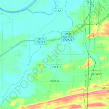
Name: Pocola topographic map, elevation, terrain.

Location: Pocola, Le Flore County, Oklahoma, 74902, United States (35.20190 -94.54965 35.31787 -94.43400)

Average elevation: 482 ft

Minimum elevation: 397 ft

Maximum elevation: 810 ft

Le Flore County trails, hiking, mountain biking, running and outdoor activities

Other topographic maps

Click on a map to view its topography, its elevation and its terrain.

Big Cedar

United States > Oklahoma > Le Flore County

Average elevation: 1,001 ft

Trestle Ford

United States > Oklahoma > Le Flore County

Average elevation: 614 ft

Tombstone Mountain

United States > Oklahoma > Le Flore County

Average elevation: 1,496 ft

Page

United States > Oklahoma > Le Flore County

Average elevation: 1,273 ft

Harvey Mountain

United States > Oklahoma > Le Flore County

Average elevation: 906 ft

Sunset Corner

United States > Oklahoma > Le Flore County

Average elevation: 482 ft

Octavia

United States > Oklahoma > Le Flore County > Octavia

Average elevation: 935 ft

Leflore

United States > Oklahoma > Le Flore County > Le Flore

Average elevation: 574 ft

Gear up for your next adventure:

🧷Carabiner Set - Durable clips for gear attachment
🩳Quick‑Dry Hiking Shorts - Comfortable and quick‑dry shorts for summer hiking
🌧️Backpack Rain Cover - Keep gear dry in wet weather
🥾Men's Hiking Boots - Durable, waterproof footwear for rugged terrain and steep inclines
🎒Hydration Pack - Hands‑free water reservoir for long hikes

As an Amazon Associate, this site earns from qualifying purchases at no extra cost to you.