Geolocate

Albion topographic map

Click on the map to display elevation.

About this map

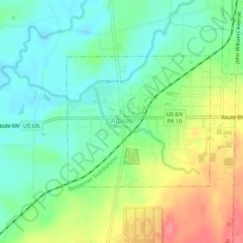
Name: Albion topographic map, elevation, terrain.

Location: Albion, Erie County, Pennsylvania, United States (41.88319 -80.37470 41.89779 -80.35321)

Average elevation: 915 ft

Minimum elevation: 827 ft

Maximum elevation: 1,066 ft

Erie County trails, hiking, mountain biking, running and outdoor activities

Other topographic maps

Click on a map to view its topography, its elevation and its terrain.

Little Hope

United States > Pennsylvania > Erie County

Average elevation: 1,421 ft

Erie

United States > Pennsylvania > Erie County > Erie

Average elevation: 833 ft

Jackson

United States > Pennsylvania > Erie County > Jackson

Average elevation: 1,306 ft

Belleview Heights

United States > Pennsylvania > Erie County

Average elevation: 1,171 ft

Gear up for your next adventure:

🌡️Handheld Weather Meters - Measure wind, temp, and pressure for safe mountain travel
🦶Hiking Gaiters - Keep debris and water out of your boots
🎒Outdoor Daypacks - Lightweight backpacks designed for carrying maps and essential gear
GPS Sports Watch - GPS watch for running, hiking and training
Backpacking Tent - Lightweight and durable tent for multi‑day hikes

As an Amazon Associate, this site earns from qualifying purchases at no extra cost to you.