Geolocate

Dispur topographic map

Click on the map to display elevation.

About this map

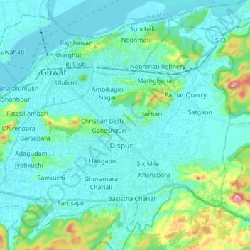
Name: Dispur topographic map, elevation, terrain.

Location: Dispur, Kamrup Metropolitan, Assam, India (26.09381 91.70725 26.20985 91.85796)

Average elevation: 312 ft

Minimum elevation: 131 ft

Maximum elevation: 1,355 ft

Other topographic maps

Click on a map to view its topography, its elevation and its terrain.

Tezpur

India > Assam > Tezpur

Average elevation: 223 ft

Jorabat

India > Assam > Sonapur

Average elevation: 499 ft

Subansiri

India > Assam > Gogamukh

Average elevation: 315 ft

Kāmrūp

India > Assam

Average elevation: 1,083 ft

Diphu

India > Assam > Diphu

Diphu is located at 25°50′N 93°26′E / 25.83°N 93.43°E / 25.83; 93.43. It has an average elevation of 186 metres (610 feet). It is about 270 km by road and 213 km by railways from Guwahati. The town is located on a beautiful hill.

Average elevation: 630 ft

Badarpur

India > Assam > Badarpur > Badarpur

Average elevation: 89 ft

Numaligarh

India > Assam > Bokakhat > Numaligarh

Average elevation: 285 ft

Gear up for your next adventure:

🧥Men's Rain Shells - Premium waterproof and breathable jackets for mountain weather
🛡️Bear Spray Outdoor - Protection in bear country hikes
🪶Camping Sleeping Pad - Comfortable sleeping pad for backpacking
📻Weather Alert Radios - Stay informed of storm risks while off-the-grid
❄️Traction Cleats - Prevent slips on icy trails during winter hikes

As an Amazon Associate, this site earns from qualifying purchases at no extra cost to you.