
Gozzano topographic map
Click on the map to display elevation.
About this map
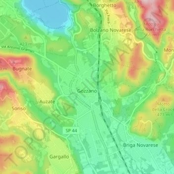
Name: Gozzano topographic map, elevation, terrain.
Location: Gozzano, Novara, Piemonte, 28024, Italia (45.72432 8.39490 45.77056 8.46185)
Average elevation: 1,270 ft
Minimum elevation: 951 ft
Maximum elevation: 1,831 ft
Other topographic maps
Click on a map to view its topography, its elevation and its terrain.
Montrigiasco
Italia > Piemonte > Novara > Arona
Il piccolo centro abitato si trova all’altitudine di 424m s.l.m. a 4,20 km dal nucleo abitato di Arona, a 0,98 km dalla frazione di Mercurago e a 2,30 km dalla frazione di Dagnente.
Average elevation: 1,289 ft
Curone
Italia > Piemonte > Novara > Castelletto sopra Ticino > Cascina Landa
Average elevation: 712 ft
Monte Cornaggia
Italia > Piemonte > Novara > Armeno
Il Cornaggia si trova in provincia di Novara, al confine tra comuni di Armeno, Nebbiuno e Massino Visconti. La sua prominenza topografica è di 229 metri.
Average elevation: 2,323 ft