Geolocate

Yuma topographic map

Click on the map to display elevation.

About this map

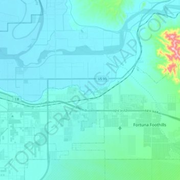
Name: Yuma topographic map, elevation, terrain.

Location: Yuma, Yuma County, Arizona, United States (32.65240 -114.65904 32.72622 -114.46608)

Average elevation: 256 ft

Minimum elevation: 125 ft

Maximum elevation: 1,565 ft

Yuma County trails, hiking, mountain biking, running and outdoor activities

Other topographic maps

Click on a map to view its topography, its elevation and its terrain.

Dateland

United States > Arizona > Yuma County

Average elevation: 453 ft

Hyder

United States > Arizona > Yuma County

Average elevation: 568 ft

Palomas

United States > Arizona > Yuma County

Average elevation: 410 ft

Araby

United States > Arizona > Yuma County > Yuma

Average elevation: 197 ft

Laguna Mountains

United States > Arizona > Yuma County

Average elevation: 463 ft

Tuscan Ranch

United States > Arizona > Yuma County > Yuma

Average elevation: 207 ft

Noah

United States > Arizona > Yuma County

Average elevation: 348 ft

Gear up for your next adventure:

🛡️Bear Spray Outdoor - Protection in bear country hikes
🚪Portable Camp Chair - Foldable chair for comfort at camp
🌐World Map Poster - Decorative world maps with topographic info
🚑Emergency Bivvies - Heat-reflective sleeping bags for survival situations
🧥Waterproof Jacket for Hiking - Breathable and rugged rain jacket for outdoor excursions

As an Amazon Associate, this site earns from qualifying purchases at no extra cost to you.